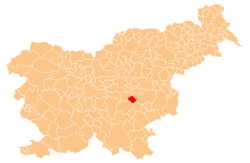
Rakovnik pri Šentrupertu
Rakovnik pri Šentrupertu (pronounced [ˈɾaːkɔu̯nik pɾi ʃɛnˈtɾuːpɛɾtu] or [ˈɾaːkɔu̯nik pɾi ʃənˈtɾuːpɛɾtu]; German: Kroisenbach[2]) is a village in the Municipality of Šentrupert in southeastern Slovenia. It lies south of Šentrupert and east of Mirna in the historical region of Lower Carniola. The railway line from Sevnica to Trebnje runs across the settlement's territory. The Municipality of Šentrupert is now included in the Southeast Slovenia Statistical Region.[3]
Rakovnik pri Šentrupertu | |
|---|---|
 Rakovnik pri Šentrupertu Location in Slovenia | |
| Coordinates: 45°57′44.12″N 15°5′36.72″E | |
| Country | |
| Traditional region | Lower Carniola |
| Statistical region | Southeast Slovenia |
| Municipality | Šentrupert |
| Area | |
| • Total | 2.07 km2 (0.80 sq mi) |
| Elevation | 251.6 m (825.5 ft) |
| Population (2002) | |
| • Total | 108 |
| [1] | |
Name
The name of the settlement was changed from Rakovnik to Rakovnik pri Šentrupertu in 1953.[4] In the past the German name was Kroisenbach.[2]
Notable people
- Count Josef Anton Barbo von Waxenstein (1863–1930), aristocrat and politician
gollark: It's designed that way. It prevents automated removal. Although half the users are somehow not smart enough to think to look prime factoring up online.
gollark: <@80813086470053888> I could actually really use this. There's already CCFuse but I never got it to work.
gollark: It has a cool new updater and better architecture.
gollark: Tau, then. Hypercycle is the latest one.
gollark: Are you on tau or hypercycle?
References
- Statistical Office of the Republic of Slovenia
- Leksikon občin kraljestev in dežel zastopanih v državnem zboru, vol. 6: Kranjsko. 1906. Vienna: C. Kr. Dvorna in Državna Tiskarna, p. 84.
- Šentrupert municipal site
- Spremembe naselij 1948–95. 1996. Database. Ljubljana: Geografski inštitut ZRC SAZU, DZS.
External links
This article is issued from Wikipedia. The text is licensed under Creative Commons - Attribution - Sharealike. Additional terms may apply for the media files.
