Kremena Ice Piedmont
Kremena Ice Piedmont (Bulgarian: ледник Кремена, romanized: lednik Kremena, IPA: [ˈlɛdnik krɛˈmɛnɐ]) is a 2.4 km long and 2.7 km wide glacier on Smith Island in the South Shetland Islands, Antarctica draining the southeast slopes of Imeon Range south of Organa Peak. Draining southeastwards to flow into Osmar Strait.

Location of Smith Island in the South Shetland Islands.

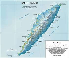
Topographic map of Smith Island.
The glacier is named after the settlements of Kremena in northeastern Bulgaria, and Upper and Lower Kremena in northwestern Bulgaria.
Location
Kremena Ice Piedmont is located at 63°04′00″S 62°38′00″W. Bulgarian mapping in 2009.
Maps
- Chart of South Shetland including Coronation Island, &c. from the exploration of the sloop Dove in the years 1821 and 1822 by George Powell Commander of the same. Scale ca. 1:200000. London: Laurie, 1822.
- L.L. Ivanov. Antarctica: Livingston Island and Greenwich, Robert, Snow and Smith Islands. Scale 1:120000 topographic map. Troyan: Manfred Wörner Foundation, 2010. ISBN 978-954-92032-9-5 (First edition 2009. ISBN 978-954-92032-6-4)
- South Shetland Islands: Smith and Low Islands. Scale 1:150000 topographic map No. 13677. British Antarctic Survey, 2009.
- Antarctic Digital Database (ADD). Scale 1:250000 topographic map of Antarctica. Scientific Committee on Antarctic Research (SCAR). Since 1993, regularly upgraded and updated.
- L.L. Ivanov. Antarctica: Livingston Island and Smith Island. Scale 1:100000 topographic map. Manfred Wörner Foundation, 2017. ISBN 978-619-90008-3-0
gollark: SCM-F078C8EE page exposed to SCM-███████, a [REDACTED] epistemoinfohazard. Results: [DATA EXPUNGED] loss of primary database [WARNING: computatiomemetic hazard detected at 0xfe7458abebc72] failure of global information networks [DATA LOST].
gollark: Will we have an O5 Council, a POTAT-O5 Council, an O6 council, an Ø Association, or what?
gollark: Maybe a test log, containing stuff like:- deleted page, reappeared after [REDACTED] minutes- deleted and locked page, locking apparently overriden, reappeared after 5 minutes- SCM primary database server RAID array temporarily set to read-only mode; entry found to have been written directly to disks- SCM-F078C8EE page edited to redirect to an unrelated anomaly; redirect removed, original content restored- [DATA LOST]
gollark: We can't have D-Class. We will have... Ŧ-Class.
gollark: * a printed photograph of an apioform, on [insert some description of the paper type and size]
References
- Kremena Ice Piedmont. SCAR Composite Gazetteer of Antarctica.
- Bulgarian Antarctic Gazetteer. Antarctic Place-names Commission. (details in Bulgarian, basic data in English)
External links
- Kremena Ice Piedmont. Adjusted Copernix satellite image

The southeast side of Smith Island from Osmar Strait
This article includes information from the Antarctic Place-names Commission of Bulgaria which is used with permission.
This article is issued from Wikipedia. The text is licensed under Creative Commons - Attribution - Sharealike. Additional terms may apply for the media files.