Kozara
Kozara (Козара) is a mountain in western Bosnia and Herzegovina, in the Bosanska Krajina region, bounded by the Sava River to the north, the Vrbas to the east, the Sana to the south, and the Una to the west. Its tallest peak is Lisina (978 m). In 1942 Kozara was the site of the Kozara Offensive, part of the Yugoslav National Liberation War and Partisan resistance during World War II.[1][2]
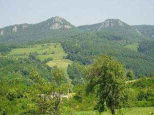
Side of the mountain called 'Kozaracki Kamen' - overlooking hamlet of Kozarac
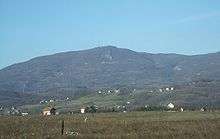
View of the tallest peak, Lisina
Peaks
| Name | Height (m) |
|---|---|
| Lisina | 978 |
| Gola planina | 876 |
| Mrakovica | 806 |
| Glavuša | 793 |
| Bešića poljana | 784 |
| Talavića poljana | 780 |
| Jarčevica | 740 |
| Vrnovačka glava | 719 |
| Benkovac-Jurišina kosa | 705 |
| Zečiji kamen | 667 |
| Kozarački kamen | 659 |
| Šupljikovac | 652 |
| Vitlovska kosa | 589 |
| Palež | 542 |
| Mednjak | 440 |
gollark: (to tag page X as being part of category Æ (yes, I have unicode support somewhat) you would just stick something like `[[tag!Æ]]` in)
gollark: Cool, yes?
gollark: So, instead of a dedicated tag system you can just use links and a list of backlinks.
gollark: The "typed" bit means that you can specify that the link is a "tag" or something, and that will be shown on both ends.
gollark: When you create a link on page X, it is shown as a backlink on page Y, *with* a snippet of the context surrounding the link.
References
- "Kozara". Kozara National Park.
- "Kozara Memorial". Memorial Museums.
| Wikimedia Commons has media related to Kozara. |
This article is issued from Wikipedia. The text is licensed under Creative Commons - Attribution - Sharealike. Additional terms may apply for the media files.