Koyva
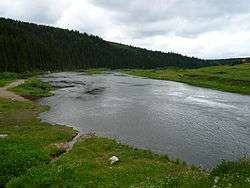
The Koyva (Russian: Койва) is a river in Perm Krai in Russia, a right tributary of the Chusovaya (Kama's basin). The river is 180 kilometres (110 mi) long, and its drainage basin covers 2,250 square kilometres (870 sq mi).[1] It starts on the western slope of the Ural Mountains, on the slopes of Mount Bolshaya Khmelikha. Its mouth is near the settlement Ust-Koyva, 66 kilometres (41 mi) from the mouth of the Chusovaya River. It is a mountain river with many rapids and shoals.
| Koyva | |
|---|---|
 | |
| Physical characteristics | |
| Source | |
| • location | Ural Mountains |
| Mouth | Chusovaya |
• coordinates | 58.2331°N 58.2039°E |
| Length | 180 km (110 mi) |
| Basin size | 2,250 km2 (870 sq mi) |
| Basin features | |
| Progression | Chusovaya→ Kama→ Volga→ Caspian Sea |
It was along the Koyva that the first ever diamonds were found in 1829 in Russia. There are urban-type settlement Tyoplaya Gora situated by the river.
Main tributaries:
- Left: Tiskos, Tyrym, Olkhovka;
- Right: Biser, Kusya.
Etymology
Name of river is a composition of Komi-Permyak words ‘koy’ (splash) and ‘va’ (water).
gollark: Integration roles?
gollark: https://discord.com/oauth2/authorize?client_id=509849474647064576&scope=bot&permissions=68608
gollark: ++about
gollark: Also, they have native async/await syntax, although if the ES team were *cool* they would just implement do notation.
gollark: Yes, that's right. Promises are a monoid in the category of endofunctors.
This article is issued from Wikipedia. The text is licensed under Creative Commons - Attribution - Sharealike. Additional terms may apply for the media files.