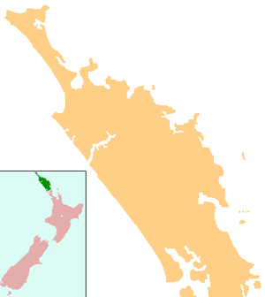
Kokopu, New Zealand
Kokopu is a locality in Northland, New Zealand. Whangarei lies about 20 km to the east.[1]
Kokopu | |
|---|---|
 Kokopu | |
| Coordinates: 35°42′24″S 174°8′42″E | |
| Country | New Zealand |
| Region | Northland Region |
| District | Whangarei District |
Education
Kokopu School is a coeducational full primary (years 1-8) school with a decile rating of 9 and a roll of 95.[2] The school was established in 1914, and for the first twenty years it operated half-time, sharing its teacher with Kara School.[3]
Notes
- Roger Smith, GeographX (2005). The Geographic Atlas of New Zealand. Robbie Burton. pp. map 24. ISBN 1-877333-20-4.
- "Te Kete Ipurangi - Kokopu School". Ministry of Education. Archived from the original on 29 September 2007. Retrieved 15 April 2008.
- McConnell, Gordon. "History of the Kokopu School". Kokopu School. Archived from the original on 14 October 2008. Retrieved 15 April 2008.
gollark: Streamed with good quality, too - 128kbps Opus.
gollark: We have excellent and good™ musical music™ which is considered music in more than 17 countries.
gollark: No, everyone else's music tastes are wrong?
gollark: https://osmarks.tk/radio/ ← TECHNICALLY CONSIDERED MUSIC
gollark: Oh, and also listen to osmarks internet radio™?
This article is issued from Wikipedia. The text is licensed under Creative Commons - Attribution - Sharealike. Additional terms may apply for the media files.