Koeye River
Koeye River (pronounced Kway[6][7]) is a river in the Canadian province of British Columbia. It originates in the Pacific Ranges of the Coast Mountains, and flows about 35 km (22 mi)[4] west to Fitz Hugh Sound, south of Bella Bella.[1] The river's watershed is about 18,000 ha (180 km2; 69 sq mi).[5]
| Koeye River | |
|---|---|
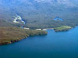 Mouth of the Koeye River | |
| Etymology | Heiltsuk word, possibly meaning "sitting on the water"[1] |
| Location | |
| Country | Canada |
| Province | British Columbia |
| Physical characteristics | |
| Source | Pacific Ranges |
| • location | Coast Mountains, British Columbia |
| • coordinates | 51°47′4″N 127°31′23″W[2] |
| • elevation | 943 m (3,094 ft)[3] |
| Mouth | Pacific Ocean |
• location | Fitz Hugh Sound, British Columbia |
• coordinates | 51°46′34″N 127°52′34″W[1] |
• elevation | 0 m (0 ft) |
| Length | 35 km (22 mi)[4] |
| Basin size | 180 km2 (69 sq mi)[5] |
The Koeye River is located on the Central Coast of British Columbia, in the Great Bear Rainforest. It empties into Fitz Hugh Sound, part of the Inside Passage. The river is within the traditional territory of the Heiltsuk, Wuikinuxv, and Nuxalk, today the Heiltsuk Nation, Wuikinuxv Nation, and Nuxalk Nation.[5][8]
The Koeye River's name comes from a Heiltsuk word, possibly meaning "sitting on the water".[1]
Course
The Koeye River originates in the Pacific Ranges of the Coast Mountains, between Rivers Inlet and Burke Channel. It flows generally west through Koeye Lake and Little Koeye Lake,[9][10] then north of the Koeye Range[11] to empty into Fitz Hugh Sound at Koeye Point.[12][2]
Natural history
The Koeye River supports Chinook, Chum, Coho, Pink, and Sockeye salmon, as well as Steelhead and Cutthroat trout.[8] Terrestrial wildlife of the Koeye watershed includes grizzly bear, American black bear, wolf, deer, cougar, mountain goat, wolverine, and North American river otter. The river's estuary is used by many waterfowl, including rare and endangered species such as the western grebe, trumpeter swan, and marbled murrelet.[8]
Protection
The Koeye River's watershed land is protected by the Koeye Conservancy, which is co-managed by the Wuikinuxv Nation and the Province of British Columbia.[8]
The river's estuary, along with the nearby Namu River at Namu, is one of the largest complexes of ancient forests of British Columbia's Central Coast. The area is listed as a Protected Area under the Great Bear Rainforest agreement.[13][14]
See also
- List of British Columbia rivers
References
- "Koeye River". BC Geographical Names.
- "Canadian 1:50K topographic maps" (map). TopoQuest.com. Retrieved 15 December 2016.
- Elevation derived from ASTER Global Digital Elevation Model, using GeoLocator, and source coordinates.
- Length calculated in Google Earth using the path tool
- "Koeye River". Qps Projects Society. Retrieved 15 December 2016.
- "Research project keeps watch over grizzlies in the Great Bear Rainforest". The Nature Conservancy. Missing or empty
|url=(help) - "Koeye Camp". QQS Projects Society. Missing or empty
|url=(help) - "Koeye Conservancy". BC Parks. Retrieved 15 December 2016.
- "Koeye Lake". BC Geographical Names.
- "Little Koeye Lake". BC Geographical Names.
- "Koeye Range". BC Geographical Names.
- "Koeye Point". BC Geographical Names.
- "Koeye Estuary". Nature Conservancy Canada. Retrieved 15 December 2016.
- "New Order for the Great Bear Rainforest". Strategic Land and Resource Planning, Province of British Columbia. Retrieved 15 December 2016.
External links
- Habitat Mapping in the Koeye River Estuary, Hakai Institute
- Study area and major spawning areas in the Koeye River, ResearchGate
- Map of Conservancies in Wuikinuxv Territory, Coastal First Nations, Great Bear Initiative