Knaresborough Viaduct
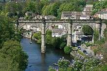
Knaresborough Viaduct is viaduct in the North Yorkshire town of Knaresborough, England. The viaduct carries the Harrogate line over the River Nidd in the town. The viaduct was supposed to have opened in 1848, but the first construction collapsed into the river very near to completion, which necessitated a new viaduct and delayed the opening of the line through Knaresborough by three years.
Knaresborough Viaduct | |
|---|---|
 Knaresborough Viaduct | |
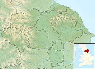
 Location within North Yorkshire | |
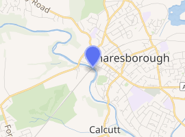
| Coordinates | 54.0084°N 1.4714°W |
| OS grid reference | |
| Carries | Harrogate Line |
| Crosses | River Nidd |
| Locale | Knaresborough, North Yorkshire |
| Other name(s) | Nidd Viaduct[note 1] |
| Owner | Network Rail |
| ICE | HEW153 |
| Preceded by | High Bridge (A59 road) |
| Followed by | B6163 road bridge |
| Characteristics | |
| Material | Gritstone |
| Total length | 4 chains (260 ft; 80 m) |
| Height | 80.5 feet (24.5 m) |
| No. of spans | 4 |
| Piers in water | 1 |
| Rail characteristics | |
| No. of tracks | 2 |
| Track gauge | 4 ft 8 1⁄2 in (1,435 mm) standard gauge |
| History | |
| Architect | Thomas Grainger |
| Construction cost | £9,803 |
| Opened | 1 October 1851 |

| |
The viaduct can be seen striking across the Nidd Gorge from the ruins of Knaresborough Castle and is a well-known viewpoint in the town. One writer has stated that it is one of the region's better known landmarks.[6]
History
The viaduct connects Knaresborough with Harrogate on the Harrogate line, in North Yorkshire, England.[7] The line was built in 1848 with the Leeds and Thirsk Railway creating a branch from their line at Starbeck railway station to go through Knaresborough and connect with the line that was being built westwards from York as part of the East and West Yorkshire Junction Railway.[8] Just as the viaduct had been almost completed, it collapsed into the River Nidd on 11 March 1848.[9] The resultant noise of the falling masonry was said to have lasted for five minutes. Whilst there was no official inquiry, it is believed that the collapse of the viaduct was down to a combination of bad workmanship, poor materials and excess water in the swollen river below as a result of heavy rain over a period of two months.[10] Despite the collapse, the centre span was still in-situ and had to be demolished before work could start again on a replacement viaduct.[11]
The fall of the viaduct necessitated a temporary Knaresborough railway station situated to the east of the present day station whilst a new viaduct was completed and the permanent station was built.[12] The collapse of the viaduct allowed a considerable amount of stone and lime to enter the river. Due to the presence of lime in the water, thousands of fish were found dead over a large stretch of the river downstream.[13] The contractors, Wilson and Benson, took the two railway companies to court as Thomas Grainger had been engaged to act as an arbitrator in the resultant argument about who should pay for the failed viaduct. Grainger decided that the railway companies should pay over £5,600, but that the two contractors must pay £2,389 and relinquish any further claims on property, materials or the right to build the new viaduct. The main complaint that Benson and Wilson had against Grainger was that he had been employed by both companies to engineer the railway line and stations, so they alleged a bias on his part.[14]
A new viaduct was started in 1848 and used the same source of stone as the previous viaduct; a quarry at Abbey Crags, part of the Nidd Gorge through Knaresborough some 1 mile (1.5 km) to the south of the viaduct.[15] The stone was quarried from the same Upper Plompton Grit that was used in the castle and other buildings in the town.[16]
A replacement viaduct was opened on 1 October 1851 costing £9,803,[17] and was constructed with castellated walls and piers to blend in with the ruined walls of Knaresborough Castle.[6][18] It consists of four arches and three piers, the middle of which stands in the water. Railway mapping lists the viaduct as being 4 chains (260 ft; 80 m), but other sources list its length to be 330 feet (100 m).[19] The viaduct is 78 feet (24 m) high, and each span is 56.9 feet (17.3 m) across in width.[20][note 2] The height of the parapets is only 35 inches (88 cm) which has led to Network Rail installing temporary fencing to protect workers when maintenance is underway on the structure.[21]
The viaduct can be seen from the castle (looking upstream along the River Nidd) and is a regular viewpoint of the structure that has attracted accolades,[22][23][24][25] though opinion is divided on the subject.[26] In his 1967 survey of the West Riding of Yorkshire, Nikolaus Pevsner stated that the viaduct was "one of the most notable railway crimes in England. To castellate the bridge does not make it a picturesque object".[27] Conversely, noted Yorkshire-born writer, J B Priestley, was in admiration of how the river reflected the viaduct and said that it "added a double beauty to the scene".[28] In a 2015 poll conducted by the Dalesman magazine, the viaduct came at number 23 out of the 50 best views in Yorkshire.[29] The viaduct is now a grade II* listed structure.[17]
Notes
- Some sources list this as being Nidd Viaduct (such as Network Rail's own documentation on the viaduct, which also lists it as only having one span).[1] Nidd Viaduct is further upstream and was part of the original Leeds & Thirsk Railway to the north, near to the village of Nidd.[2] This viaduct is still standing and carries the Nidderdale Greenway across it.[3] William Weaver Tomlinson, also states that the "Nidd Viaduct [in Knaresborough] opened on 1 October 1851".[4] To further complicate matters, Nidd Viaduct is also known as Bilton Viaduct.[5]
- Speight claims that the viaduct is 338 feet (103 m) long, 80.5 feet (24.5 m) from water to rail level and that each span is 56 feet 4.5 inches (17.183 m) in width.[13]
References
- "Route Specifications 2019 London North Eastern and East Midlands" (PDF). networkrail.co.uk. April 2019. p. 98.
- Speight 1894, p. 352.
- "Nidderdale Greenway - Harrogate to Ripley Cycle Route". sustrans.org.uk. Retrieved 9 September 2019.
- Tomlinson 1914, p. 511.
- "Long and winding road nears end". infoweb.newsbank.com. 30 March 2012. Retrieved 9 September 2019.
- Bairstow, Martin (1986). Railways around Harrogate. Pudsey: Martin Bairstow. p. 39. ISBN 0-95103023-X.
- "Blaze breaks out in train on viaduct". BBC News. 15 April 2016. Retrieved 9 September 2019.
- Body, Geoffrey (1989). Railways of the Eastern Region. Wellingborough: Patrick Stephens. pp. 97–98. ISBN 1-85260-072-1.
- Tomlinson 1914, p. 488.
- Chrystal, Paul (2017). Knaresborough history tour. Stroud: Amberley. p. 17. ISBN 9781445671093.
- "Total destruction of the Viaduct over the River Nidd at Knaresborough". The Standard (9, 756). Column C. 13 March 1848. p. 3. OCLC 50161391.
- "Disused Stations: Knaresborough Temporary Station". www.disused-stations.org.uk. Retrieved 9 September 2019.
- Speight 1894, p. 305.
- "The Nidd Viaduct". The York Herald (4, 025). Column F. 1 December 1849. p. 7. OCLC 877360086.
- Speight 1894, p. 258.
- "Strategic Stone Study A Building Stone Atlas of North Yorkshire, West" (PDF). bgs.ac.uk. December 2017. p. 26. Retrieved 9 September 2019.
- Historic England. "Knaresborough Viaduct (Grade II*) (1149911)". National Heritage List for England. Retrieved 9 September 2019.
- Young, Alan (2015). Lost stations of Yorkshire; the West Riding. Kettering: Silver Link. p. 39. ISBN 978-1-85794-438-9.
- KCACA 2008, p. 31–32.
- Rennison, Robert William, ed. (1996). "5: York and North Yorkshire". Civil Engineering Heritage: Northern England (2 ed.). London: Institute of Civil Engineers. p. 154. ISBN 07277-2518-1.
- "Fears over Knaresborough viaduct fence plan". infoweb.newsbank.com. 9 May 2016. Retrieved 9 September 2019.
- KCACA 2008, p. 10.
- KCACA 2008, p. 29.
- Johnstone, Charlotte (13 May 2019). "The Yorkshire spa town with a gruesome past and a strange present". The Telegraph. Retrieved 10 September 2019.
- Drysdale, Laura (18 March 2019). "Viaduct town of Knaresborough has history at turn of every corner". The Yorkshire Post. Retrieved 10 September 2019.
- Simon, Jos (2015). The rough guide to Yorkshire (2 ed.). London: Rough Guides. p. 169. ISBN 9781409371045.
- Binney, Marcus (20 November 2009). "From mills to Modern: the treasures of the West Riding". The Times. Retrieved 9 September 2019.
- Chrystal, Paul (2017). Knaresborough history tour. Stroud: Amberley. p. 18. ISBN 9781445671093.
- "The top 50 views of Yorkshire". infoweb.newsbank.com. 27 August 2015. Retrieved 9 September 2019.
Sources
- Speight, Harry (1894). Nidderdale and the garden of the Nidd: a Yorkshire Rhineland. Being a complete account, historical, scientific, and descriptive, of the beautiful valley of the Nidd. London: Elliott Stock. OCLC 6678674.CS1 maint: ref=harv (link)
- Knaresborough Conservation Area Character Appraisal (PDF). harrogate.gov.uk (Report). 10 December 2008. Retrieved 9 September 2019.
- Tomlinson, William Weaver (1914). The North Eastern Railway; its Rise and Development. London: Longmans & Co. OCLC 1049905072.CS1 maint: ref=harv (link)