Klipriviersberg Nature Reserve
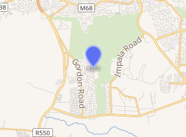
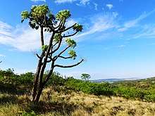
Klipriviersberg Nature Reserve is a nature reserve of 640 hectares (1,600 acres) consisting of veld and koppies (hills) run by the Johannesburg City Parks and is located 11 kilometres (6.8 mi) south of Johannesburg. Home to many species of flora and bird life, it is also home to large and small mammals such as blesbok, zebra, wildebeest and duiker. The reserve has a number of hikes and trails, archaeological sites with the Bloubos spruit flowing through the area.
| Klipriviersberg Nature Reserve | |
|---|---|

| |
| Type | Nature reserve |
| Location | Peggy Vera Road, Kibler Park, Gauteng |
| Nearest city | Johannesburg |
| Coordinates | 26°18′13″S 28°0′39″E |
| Area | 680 hectares (1,700 acres) |
| Created | 1984 |
| Operated by | Johannesburg City Parks |
| Open | All year |
| Camp sites | None |
| Hiking trails | Nine |
| Plants | 650 – 700 species |
| Species | Large game 215 birds species |
| Parking | Main Entrance – Peggy Vera Road, Kibler Park Northern entrance – Frandaph Drive, Mondeor |
| Website | www klipriviersberg |
History
Prehistory saw the area inhabited by stone age man who hunted in the area with the location claimed to have the highest concentration of identified Iron Age sites on the Witwatersrand with the discovery of artefacts dating back 250,000 years.[1][2][3]
The Sotho-Tswana peoples would later settle in the area in the 1400s and would leave the location around 1800 when possibly climate changes and the movement of more militant tribes into the area saw their departure to Botswana.[4] Their lifestyle consisted of animal husbandry and the growing millet, sorghum and later maize imported into Africa by the Portuguese traders.[4]
Around 1850, Voorttrekker Sarel Marais bought land on a western portion of the Rietvlei farm part of which is the reserve today, and used it for grazing and peach farming.[5] His descendants would eventually sell the farm in 1914 to the Quilliam family who used it for dairy farming and as a piggery.[5] By 1939, the Quilliam family had sold the land to the City of Johannesburg.[5]
After the discovery of gold in the Witwatersrand, the shortage of water saw a proposal to build a dam in the northern part of the reserve.[6] To be called the Vierfontein Dam, work ended on it as the Second Boer War broke out and all that remains across the spruit is the remains of a weir.[6] After the war the proposal was found to be uneconomical and the Rand Water Board chose the Vaal Dam barrage as a better option.[6]
During the Second Boer War, the hills around the reserve were used by Boers in the defence of Johannesburg against the southern advance of the British forces under Lord Roberts from the direction of Vereeniging.
In the late 1970s residents of the area petitioned the Johannesburg City Council to declare the area as nature reserve.[7] The council asked the residents to form an association to assist the council in the proposed reserves management and was formed as the Klipriviersberg Nature Reserve Association and the nature reserve was proclaimed in 1984.[7]
Fauna and flora

Large mammals such as Black Wildebeest, Blesbok, Springbok, Red Hartebeest and Zebra are found in the reserve with approximately 240 of these large animals.[8] Also found are numerous small mammals. 215 species of bird life have been recorded in the reserve as well as snakes, geckos, lizards, skinks and terrapins.[9] It is also a haven for insect life such as butterflies and spiders. There is said to be between 650—700 species of plants in the reserve. What has been catalogued are over 340 wild flowers, 67 tree and shrub types as well as 70 grasses species.[10]
Recreation
The fenced reserve is open all year round from dawn to dusk. The ruins of Marais' farmhouse, wagon shelter and family cemetery can still be seen today.[5] There is also nine trails to hike consisting of 20 kilometres (12 mi) in total.[11] To the north of the reserve is the Silent Pool, the result of a hole dug during the construction of the proposed dam. The reserve can be entered at two points:
- The main entrance in Peggy Vera Road, Kibler Park.[lower-alpha 1]
- Silent Pool entrance in from Frandalph Drive, Mondeor.[lower-alpha 2]
References
- Peggy Vera Rd entrance 26°18′14″S 28°00′39″E
- Frandalph Dr entrance 26°17′00″S 28°00′35″E
- "Klipriviersberg Nature Reserve". Footprint Hiking Club. Archived from the original on 29 July 2015. Retrieved 1 November 2015.
- "Klipriviersberg Nature Reserve". Johannesburg City Parks and Zoo. Retrieved 1 November 2015.
- Stephen, Cousins; Joan, Faiola; Vermaak, Vanessa (June 2014). "Klipriviersberg – Johannesburg's green jewel of the south". Veld & Flora. 100 (2): 68–71. ISSN 0042-3203. Retrieved 3 January 2016.
- "History: Sotho-Tswana Settlers". Klipriviersberg Nature Reserve Association. Archived from the original on 14 January 2016. Retrieved 1 November 2015.
- "History: Sarel Marais". Klipriviersberg Nature Reserve Association. Archived from the original on 14 January 2016. Retrieved 1 November 2015.
- "Vierfontein". Klipriviersberg Nature Reserve Association. Archived from the original on 14 January 2016. Retrieved 1 November 2015.
- "About Us". Klipriviersberg Nature Reserve Association. Archived from the original on 14 January 2016. Retrieved 1 November 2015.
- "Mammals". Klipriviersberg Nature Reserve Association. Archived from the original on 14 January 2016. Retrieved 1 November 2015.
- "Birds". Klipriviersberg Nature Reserve Association. Archived from the original on 14 January 2016. Retrieved 1 November 2015.
- "Flora". Klipriviersberg Nature Reserve Association. Archived from the original on 14 January 2016. Retrieved 1 November 2015.
- "Hiking in the Reserve". Klipriviersberg Nature Reserve Association. Archived from the original on 26 November 2015. Retrieved 1 November 2015.
External links
- Map of the Nature Reserve, from jhbcityparks.com
- Klipriviersberg Nature Reserve Association
- Hiking the Reserve