Kiang (Gambia)
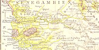
Kiang (variant spelling: Kian) was a historical empire within the West African state of The Gambia and also the name of the region it covered. Its area is now the districts of Kiang Central, Kiang East, and Kiang West in the Lower River Division of the present-day country refer to this empire. The Kiang West National Park is also on the territory of the former empire.
History
The empire was one of nine Mandinka empires on the southern bank of the Gambia River in the early 19th century. It stretched in the west from where the Bintang Bolong joins the Gambia to the east to the point known as Devil Point, around ten kilometers from Soma. The empire was separated from the Fogny Empire in the south by the Bintang Bolong. In the east it bordered on Jarra Empire.
The towns of Tankular and Tendaba were the main ports on the Gambia, where Europeans also traded.
Reference
- Arnold Gailey, Harry A. Hughes. Historical Dictionary of the Gambia. The Scarecrow Press, Inc., 1999, ISBN 081083660-2