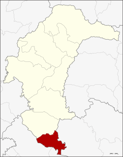
Kho Wang District
Kho Wang (Thai: ค้อวัง, pronounced [kʰɔ́ː wāŋ]) is a district in the south of Yasothon Province in northeastern Thailand.
Kho Wang ค้อวัง | |
|---|---|
 District location in Yasothon Province | |
| Coordinates: 15°22′4″N 104°21′28″E | |
| Country | Thailand |
| Province | Yasothon |
| Area | |
| • Total | 150 km2 (60 sq mi) |
| Population (2005) | |
| • Total | 26,424 |
| • Density | 176.16/km2 (456.3/sq mi) |
| Time zone | UTC+7 (ICT) |
| Postal code | 35160 |
| Geocode | 3507 |
History
Kho Wang was once called Non Kho village, but a monk named Wang from Kanthararom District in Sisaket Province came to live and teach in the area. The monk so inspired faith in the people of the region that many moved to the village, and the villagers changed the name of the village to Kho Wang in honor of the monk.
Geography
Neighboring districts are (from the north clockwise): Maha Chana Chai of Yasothon Province; Khueang Nai of Ubon Ratchathani Province; Yang Chum Noi and Rasi Salai of Sisaket Province.
Administration
The district is divided into four sub-districts (tambons), with 45 villages (mubans).
|
Schools
The secondary schools in Kho Wang are:
- Kho Wang Witthayakhom School (โรงเรียนค้อวังวิทยาคม)
- Bandongmaree School (โรงเรียนบ้านดงมะหรี่)
gollark: Hint: the answer is not 286915.
gollark: ***maths***
gollark: Katze: Differentiate 3x²+9x or DIE!
gollark: I don't think most stuff uses Extended ASCII anyway, so it's either 128 or some stupidly large amount usually.
gollark: It's not as if only 255 characters exist.
This article is issued from Wikipedia. The text is licensed under Creative Commons - Attribution - Sharealike. Additional terms may apply for the media files.