Khirbet Kefireh
Khirbet Kefireh (alt. sp., Kefire, el-Kefirah; coordinates 1602.1375) is a modern Palestinian village just north of Qatanna, West Bank on a hilltop covering about 4-5 acres. It appears in the Survey of Western Palestine map compiled in the 1870s, and most Bible dictionaries identify it with Chephirah.[1][2]
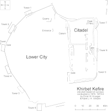 Site plan. | |
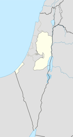 Shown within the Palestinian territories | |
| Location | |
|---|---|
| Coordinates | 31.8309°N 35.106769°E |
Dutch archaeologist Karel J.H. Vriezen extensively surveyed the site during September 1970, June and July 1973, and again in March and July 1974. The site contains two major sections: an upper citadel on the east side near its elevation peak (774 m), and a lower village on the west side. Additionally, three graves were examined about 150 meters to the northeast of the site.[3]
Vriezen found evidence for major architectural changes dating to the Iron-II and Byzantine eras, and pottery shards spanning the Early Bronze, Iron I, Iron II, Hellenistic, Roman, and Byzantine periods. Highlights include a jar handle bearing a LMLK seal impression,[4] and another handle bearing a pre-fired plus (+) mark.[5]
The walls of the site included nine towers and three gates. A cistern and a quarry were found enclosed within the city walls.
Excavations are no longer possible due to the presence of modern habitations.
Notes
- International Standard Bible Encyclopedia: "It is represented by the modern Kefireh, to the Southwest of Gibeon, and North of Karyat el-`Anab. It stands on high ground, with many ancient remains."
- Eerdmans Dictionary of the Bible: "The city has been identified with modern Khirbet el-Kefireh (160137), ca. 8km. (5 mi.) WSW of el-Jib (Gibeon)."
- ZDPV 91, Abb. 2.
- ZDPV 91, p. 143.
- ZDPV 91, p. 146.
References
- Keel, O.; Küchler, M. (1982). Orte und Landschaften der Bibel II. Der Süden, Zürich & Göttingen. p. 802.
- Rainey, Anson F.; Notley, R. Steven (2005). The Sacred Bridge. Carta. p. 126.
- Vriezen, Karel J. H. (1975). "Hirbet Kefire - eine Oberflächenuntersuchung". ZDPV. 91:1: 135–58.
- Vriezen, K. (1977). "Chronique archéologique--Khirbet Kefire". Revue Biblique. 84:3 (July): 412–6. External link in
|journal=(help)