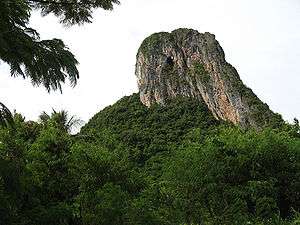
Khao Ok Thalu
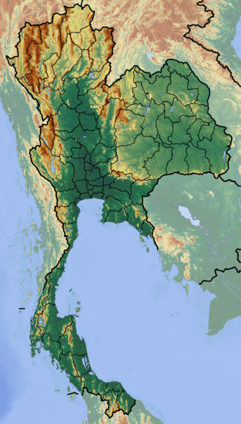
Khao Ok Thalu (Thai: เขาอกทะลุ) or Phukhao Ok Thalu (ภูเขาอกทะลุ), is a mountain in Phatthalung Province, Thailand. It is a karstic formation.
| Khao Ok Thalu | |
|---|---|
 | |
| Highest point | |
| Elevation | 177 m (581 ft) |
| Listing | List of mountains in Thailand |
| Coordinates | 7°37′30″N 100°05′30″E |
| Geography | |
 Khao Ok Thalu Thailand | |
| Location | Phatthalung, Thailand |
| Parent range | Tenasserim Hills |
| Geology | |
| Mountain type | karstic |
| Climbing | |
| Easiest route | drive |

Provincial seal of PhatThalung
Tourism
This mountain is east of the Phatthalung railway station. It can be accessed from Wat Khuha Sawan via Highway 4047. There is a flight of stairs leading to the mountaintop where there is a Buddhist shrine overlooking the city of Phatthalung. The mountain is named after a hole near the top.
Khao Ok Thalu is an unusually-shaped mountain, clearly visible from afar. It has symbolic significance in Phatthalung[1] and appears in somewhat stylized form on the provincial seal of PhatThalung.
gollark: Otherwise is fine.
gollark: You are expected to be serious in use of owner powers and not, I don't know, randomly ban people like lyricly.
gollark: People are enjoying new things. You seem excessively concerned about the "seriousness" of the server and I don't think this is very good.
gollark: There's plenty of justification here.
gollark: Doesn't say much about seriousness or whatever.
External links
This article is issued from Wikipedia. The text is licensed under Creative Commons - Attribution - Sharealike. Additional terms may apply for the media files.