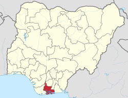
Khana, Rivers
Khana is a Local Government Area in Rivers State, Nigeria. Its administrative seat is in the town of Bori.
Khana | |
|---|---|
LGA | |
 Khana | |
| Coordinates: 4°42′N 7°21′E | |
| Country | Nigeria |
| State | Rivers State |
| Date created | 1992 |
| Seat | Bori |
| Area | |
| • Total | 220 sq mi (560 km2) |
| Population (2006) | |
| • Total | 294,217 |
| Time zone | UTC+1 (WAT) |
It has an area of 560 km² and a population of 294,217 at the 2006 census. The local language is the Khana language.
The postal code of the area is 504.[1]
References
- "Post Offices- with map of LGA". NIPOST. Archived from the original on 2009-10-07. Retrieved 2009-10-20.
Local government areas of Rivers State | ||
|---|---|---|
| LGAs |
|  |
Khana has three Districts Headquartered, Namely, Nyokhana, Kenkhana and Babbe that formed the Six kingdoms in Ogoni Kingdom.
Some of the villages in Nyorkhana are Opuoko,Kalaoko,Taabaa,Beeri,Sogho, etc.
Some of the villages in Kenkhana are Bane,Kono,Buan,Duburo Wiiyaakara etc.
Some of the villages in Babbe are Boue,Kaa,Sii, Zaakpon, Kanni Babbe etc.
This article is issued from Wikipedia. The text is licensed under Creative Commons - Attribution - Sharealike. Additional terms may apply for the media files.