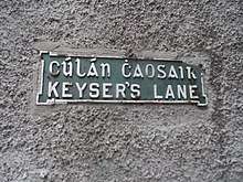
Keyser's Lane
Keyser's Lane (or Keyser's Hill, Kezer's Lane, Keizer Street, Keyzer-street) is a street name found in several former Viking towns in Ireland.[1]

Street sign in Wexford
The name generally applies to a street which runs from the medieval town centre down to the quays or harbour, and is believed to derive from Old Norse keisa, meaning "bend," perhaps a reference to the steep slope of the hill or the curve of the river.[2] Holinshed's Chronicles (1575) mentions that it is an ancient name of uncertain origin. Other sources give "lane to the quays" or "ship wharf" as its meaning; however, "quay" is a Celtic/French word, not Norse.[3][4][5]
Locations

Entrance to Keyser's Lane, Wexford
- Cork: Keyser's Hill (also called Keyser's Lane) is the name of a lane running from Proby's Quay up to Elizabeth Fort, on the south bank of the south branch of the Lee.[6]
- Drogheda: Keyser's Lane (also spelled Kezer's Lane, today called "Highlanes") connects Bachelors Lane with St Laurence's Street.[7][8]
- Dublin: Keyser's Lane was located in The Liberties and connected Cook Street to Newgate Street (today called Cornmarket). In the 19th century it was nicknamed "Kissarse Lane," apparently because the stones were slippery when wet and pedestrians sometimes fell on their bottoms.[9]
- Waterford: Keizer Street, formerly called Keyser's Lane or Keyzer-street, connects High Street to the quays.[10]
- Wexford: The best-known example, Keyser's Lane in Wexford is well-preserved and runs from High Street to Crescent Quay.[11] It is entered via an archway and is walled and roofed.[12][13][14]
gollark: People will and do notice/care about the advertising, forced updates and random Candy Crush installs.
gollark: It's good *enough* for most people, but also not actually particularly good.
gollark: Also "node-os".
gollark: http://runtimejs.org/Apparently this exists?!
gollark: Don't worry.
References
- Commons, Great Britain Parliament House of (March 2, 1900). "Sessional Papers". H.M. Stationery Office – via Google Books.
- Stridmann, Tim. "K â€" A Concise Dictionary of Old Icelandic â€" Словари â€" Ð¡ÐµÐ²ÐµÑ€Ð½Ð°Ñ Ð¡Ð»Ð°Ð²Ð°". Norrœn Dýrð (Северная Слава) (in Icelandic). Retrieved 2020-03-01.
- The Irish Times (Saturday, March 18, 1978, page 11)
- Archaeology, Irish (April 4, 2019). "Keyser's lane, Wexford town. This medieval thoroughfare gets its name from Old Norse and roughly means 'lane to the quays'. Similar street names are found in the Viking towns of Cork, Dublin and Waterford.pic.twitter.com/cZ0BJcPbNN".
- "The Vikings in Munster (PDF)" (PDF).
- The Irish Times (Monday, October 21, 1974, page 10)
- "Wrong name on Keysers Lane?". independent. 2013-01-14. Retrieved 2020-03-01.
- "Drogheda Museum News & Views: Tonight ~ Walk & Talk In The Company Of Brendan Matthews". July 29, 2015.
- Warburton, John; Whitelaw, James; Walsh, Robert (March 2, 1818). "History of the City of Dublin: From the Earliest Accounts to the Present Time : Containing Its Annals ... to which are Added, Biographical Notices of Eminent Men ... ; in Two Volumes, Illustrated with Numerous Plates, Plans, and Maps". Cadell and Davies – via Google Books.
- "Saothar". Irish Labour History Society. March 2, 2002 – via Google Books.
- "Are these the best places in Ireland?". The Irish Times.
- "Keyser's Lane, Wexford". Wexford Hub.
- Crescent Quay
- "Wexford Street Names". RTÉ Archives.
This article is issued from Wikipedia. The text is licensed under Creative Commons - Attribution - Sharealike. Additional terms may apply for the media files.