Kentucky Route 766
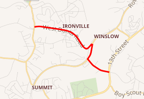
Kentucky Route 766 (KY 766) is a state maintained highway located near Ashland, Kentucky. It is used as a connector route between KY 5 and U.S. Route 60 (US 60) and runs for a distance of two miles (3.2 km). It is the primary route through the unincorporated community of Ironville, which is a suburb of Ashland.
| |
|---|---|
| |
| Route information | |
| Maintained by KYTC | |
| Length | 2.044 mi[1] (3.289 km) |
| Major junctions | |
| West end | |
| East end | |
| Location | |
| Counties | Boyd |
| Highway system | |

Route description
KY 766 begins at an intersection with KY 5 on the west side of Ironville. It heads east along Donta Road. Near Roberts Road, Donta Road curves to the south and then back to the north where it intersects KY 1134. KY 766 switches back onto Roberts Road and heads south. Shortly thereafter, it turns east onto Bob McCullough Drive, while KY 3292 continues south on Roberts Road. The street heads southeast for a short way before it ends at US 60.[2]
Major intersections
The entire route is in Ironville, Boyd County.
| mi[1] | km | Destinations | Notes | ||
|---|---|---|---|---|---|
| 0.000 | 0.000 | Western terminus | |||
| 1.261 | 2.029 | Western terminus of KY 1134 | |||
| 1.550 | 2.494 | Northern terminus of KY 3292 | |||
| 2.044 | 3.289 | Eastern terminus | |||
| 1.000 mi = 1.609 km; 1.000 km = 0.621 mi | |||||
References
- Commonwealth of Kentucky. "Official DMI Route Log". Retrieved September 4, 2011.
- Google (September 4, 2011). "Kentucky Route 766" (Map). Google Maps. Google. Retrieved September 4, 2011.