Kentucky Route 716
Kentucky Route 716 (KY 716) is a 1.565-mile-long (2.519 km), north–south highway running through Summit in Boyd County.
| ||||
|---|---|---|---|---|
| ||||
| Route information | ||||
| Maintained by KYTC | ||||
| Length | 1.565 mi[1] (2.519 km) | |||
| Major junctions | ||||
| South end | ||||
| North end | ||||
| Location | ||||
| Counties | Boyd | |||
| Highway system | ||||
| ||||

Route description
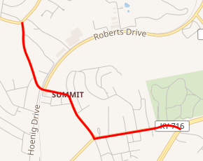
KY 716 begins at the intersection of Little Garner Road and U.S. Route 60 (US 60) in Summit. It heads west along Little Garner Road for one-half mile (0.80 km), where it intersects KY 3293 and Summit Road. It turns north onto Summit Road, which it stays on for the rest of its route. The road passes the Federal Correctional Institution, Ashland. Just short of a railroad crossing, it intersects Roberts Road, which carries KY 3292. KY 716 crosses the railroad tracks and continues north. The route ends at KY 5.[2]
Major intersections
The entire route is in Summit, Boyd County.
| mi[1] | km | Destinations | Notes | ||
|---|---|---|---|---|---|
| 0.000 | 0.000 | Southern terminus | |||
| 0.565 | 0.909 | Eastern terminus of KY 3293 | |||
| 1.050 | 1.690 | Southern terminus of KY 3292 | |||
| 1.565 | 2.519 | Northern terminus | |||
| 1.000 mi = 1.609 km; 1.000 km = 0.621 mi | |||||
gollark: 1.7361111 mHz.
gollark: What an excellent code guessing entry. Thanks for showing me it.
gollark: That's only 0.00011574074 Hz, totally doable.
gollark: But I need nulls in my text.
gollark: Or they may just have renamed it in the API and not real life™.
References
- Commonwealth of Kentucky. "Official DMI Route Log". Retrieved September 4, 2011.
- Google (September 4, 2011). "Kentucky Route 716" (Map). Google Maps. Google. Retrieved September 4, 2011.
External links
This article is issued from Wikipedia. The text is licensed under Creative Commons - Attribution - Sharealike. Additional terms may apply for the media files.