Kentucky Route 291
Kentucky Route 291 (KY 291) is a 6.3-mile-long (10.1 km) state highway in the U.S. state of Kentucky. The highway travels through mostly rural areas of Hopkins County.
| ||||
|---|---|---|---|---|
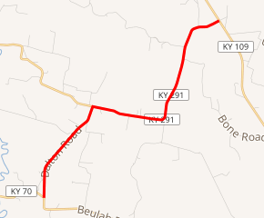
KY 291 highlighted in red | ||||
| Route information | ||||
| Maintained by KYTC | ||||
| Length | 6.3 mi[1] (10.1 km) | |||
| Major junctions | ||||
| South end | ||||
| North end | ||||
| Location | ||||
| Counties | Hopkins | |||
| Highway system | ||||
| ||||

Route description
KY 291 begins at an intersection with KY 70 (Beulah Road) south-southwest of Dalton, within Hopkins County. It travels to the north-northeast and curves to the northeast. It curves back to the north-northeast and passes Holloman Cemetery before traveling through Dalton. Just north of the community, the highway intersects the eastern terminus of KY 1294 (Government Road). At this intersection, KY 291 turns right, traveling to the east-southeast. It curves to the north-northeast and crosses over Lick Creek. The highway curves to the east-northeast and meets its northern terminus, an intersection with KY 109 (Rabbit Ridge Road). Here, the roadway continues as Stoney Point Church Lane.[1]
Major intersections
The entire route is in Hopkins County.
| Location | mi[1] | km | Destinations | Notes | |
|---|---|---|---|---|---|
| | 0.0 | 0.0 | Southern terminus | ||
| | 2.3 | 3.7 | Eastern terminus of KY 1294 | ||
| | 6.3 | 10.1 | Northern terminus | ||
| 1.000 mi = 1.609 km; 1.000 km = 0.621 mi | |||||
See also


References
- Google (June 1, 2016). "Kentucky Route 291" (Map). Google Maps. Google. Retrieved June 1, 2016.