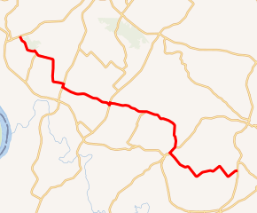
Kentucky Route 270
Kentucky Route 270 (KY 270) is a 27.5-mile-long (44.3 km) state highway in the U.S. state of Kentucky. The highway travels through mostly rural areas of Union and Webster counties.
| ||||
|---|---|---|---|---|

KY 270 highlighted in red | ||||
| Route information | ||||
| Maintained by KYTC | ||||
| Length | 27.5 mi[1][2] (44.3 km) | |||
| Major junctions | ||||
| West end | ||||
| East end | ||||
| Location | ||||
| Counties | Union, Webster | |||
| Highway system | ||||
| ||||
Route description
Union County
KY 270 begins at an intersection with KY 130 east-northeast of Henshaw, within Union County. It travels to the south-southeast and curves to the northeast. It intersects KY 492. The two highways have a brief concurrency to the southeast. After they split, KY 270 curves to the east-southeast. It curves to a due south direction. The highway curves to the east-southeast and intersects U.S. Route 60 (US 60). The two highways have a brief concurrency to the south-southwest. When they split, KY 270 resumes its east-southeast direction. It intersects the western terminus of KY 1177 and crosses over Smith Ditch. The highway has a very brief concurrency with KY 141. During their concurrency, they travel to the north-northeast and cross over Bishop Ditch. KY 270 heads to the east-southeast and crosses over Bordley Ditch. Then, it enters Webster County.[1]
Webster County
KY 270 intersects the northern terminus of KY 2837 in Hearin. After it intersects the southern terminus of KY 2838, it crosses over Caney Fork and then curves to the south-southwest. The highway has a brief concurrency with KY 132. They split just northeast of Clay. KY 270 travels to the southeast and passes Odd Fellows Cemetery. The highway crosses over Craborchard Creek and Fredericks Ditch. It curves to the northeast and then the east-northeast. Then, it intersects the northern terminus of KY 293. KY 270 travels to the northeast and enters Lisman. There, it passes Lisman Cemetery, intersects the southern terminus of KY 874, and curves to the southeast. It curves back to the northeast and then to the east-northeast and meets its eastern terminus, an intersection with US 41 Alt.[1][2]
Major intersections
| County | Location | mi[1][2] | km | Destinations | Notes |
|---|---|---|---|---|---|
| Union | | 0.0 | 0.0 | Western terminus | |
| | 2.0 | 3.2 | Western end of KY 492 concurrency | ||
| | 2.3 | 3.7 | Eastern end of KY 492 concurrency | ||
| | 6.6 | 10.6 | Western end of US 60 concurrency | ||
| | 6.9 | 11.1 | Eastern end of US 60 concurrency | ||
| | 9.5 | 15.3 | Western terminus of KY 1177 | ||
| | 11.2 | 18.0 | Western end of KY 141 concurrency | ||
| | 11.4 | 18.3 | Eastern end of KY 141 concurrency | ||
| Webster | Hearin | 14.6 | 23.5 | Northern terminus of KY 2837 | |
| | 15.7 | 25.3 | Southern terminus of KY 2838 | ||
| | 19.4 | 31.2 | Western end of KY 132 concurrency | ||
| | 20.0 | 32.2 | Eastern end of KY 132 concurrency | ||
| | 24.8 | 39.9 | Northern terminus of KY 293 | ||
| Lisman | 25.4 | 40.9 | Southern terminus of KY 874 | ||
| | 27.5 | 44.3 | Eastern terminus | ||
1.000 mi = 1.609 km; 1.000 km = 0.621 mi
| |||||
See also


References
- Google (May 30, 2016). "Kentucky Route 270 (Western terminus to KY 2838)" (Map). Google Maps. Google. Retrieved May 30, 2016.
- Google (May 30, 2016). "Kentucky Route 270 (KY 2838 to eastern terminus)" (Map). Google Maps. Google. Retrieved May 30, 2016.
