Kentucky Route 258
Kentucky Route 258 (KY 258) is a 10.156-mile-long (16.344 km) state highway in Kentucky that runs from JY 56 east of Sebree to KY 56 in rural Daviess County southwest of Owensboro.
| ||||
|---|---|---|---|---|
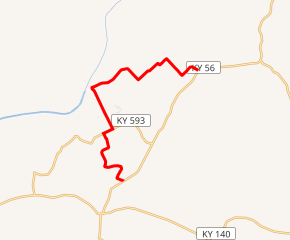
KY 258 highlighted in red | ||||
| Route information | ||||
| Maintained by KYTC | ||||
| Length | 10.156 mi[1] (16.344 km) | |||
| Major junctions | ||||
| West end | ||||
| East end | ||||
| Location | ||||
| Counties | McLean, Daviess | |||
| Highway system | ||||
| ||||

Major intersections
| County | Location | mi[1] | km | Destinations | Notes |
|---|---|---|---|---|---|
| McLean | | 0.000 | 0.000 | Western terminus | |
| | 2.845 | 4.579 | Western end of KY 593 concurrency | ||
| | 3.213 | 5.171 | Eastern end of KY 593 concurrency | ||
| Daviess | | 10.156 | 16.344 | Eastern terminus | |
1.000 mi = 1.609 km; 1.000 km = 0.621 mi
| |||||
gollark: Yes.
gollark: I offloaded the job of making my 4D tic-tac-toe game work.
gollark: How would it be able to do smart things like construct multiple lines at once?
gollark: I dislike hardcoded strategies, but I suppose this could be done.
gollark: If they got a fab, they could not operate it.
References
- "HIS Official Milepoint Route Log Report". Kentucky Transportation Cabinet. Retrieved June 3, 2016.
This article is issued from Wikipedia. The text is licensed under Creative Commons - Attribution - Sharealike. Additional terms may apply for the media files.