Kentucky Route 215
Kentucky Route 215 (KY 215) is a 5.6-mile-long (9.0 km) state highway in the U.S. state of Kentucky. The highway connects mostly rural areas of Harlan County with Evarts.
| ||||
|---|---|---|---|---|
KY 215 highlighted in red | ||||
| Route information | ||||
| Maintained by KYTC | ||||
| Length | 5.6 mi[1] (9.0 km) | |||
| Major junctions | ||||
| West end | ||||
| East end | Turner Creek Road near Dizney | |||
| Location | ||||
| Counties | Harlan | |||
| Highway system | ||||
| ||||

Route description
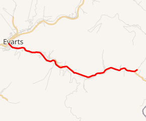
KY 215 begins at an intersection with KY 38 (Main Street) in Evarts, within Harlan County, where the roadway continues as Bridge Street. It travels to the southeast. At Lipfird Street, it curves to the east-southeast. It curves to the east-northeast, paralleling Yocum Creek. It curves to the south-southeast and southeast before leaving the city limits of Evarts. It curves to the east-southeast and crosses over the creek. The highway briefly heads to the east-northeast before it curves to the southeast and crosses over the creek again. It passes Black Mountain Elementary School and enters Redbud. It then intersects KY 2429 (Black Mountain Road) in Kenvir. The highway curves to the east-northeast, passes a U.S. Post Office, and crosses over Yocum Creek again. It curves to the southeast and then gradually curves to the northeast. The highway travels through Dizney before intersecting the western terminus of KY 3458 (Yocum Creek Road). KY 215 curves to the northeast and ends, while Turner Creek Road continues to the northeast to a dead end.[1]
Major intersections
The entire route is in Harlan County.
| Location | mi[1] | km | Destinations | Notes | |
|---|---|---|---|---|---|
| Evarts | 0.0 | 0.0 | Western terminus | ||
| Kenvir | 2.2 | 3.5 | |||
| | 5.5 | 8.9 | Western terminus of KY 3458 | ||
| | 5.6 | 9.0 | Turner Creek Road north | Eastern terminus | |
| 1.000 mi = 1.609 km; 1.000 km = 0.621 mi | |||||
See also


References
- Google (May 26, 2016). "Kentucky Route 215" (Map). Google Maps. Google. Retrieved May 26, 2016.