Kentucky Route 178
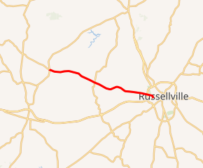
Kentucky Route 178 (KY 178) is a 12.200-mile-long (19.634 km) state highway in Kentucky that travels from KY 106 and KY 507 northeast of Elkton to U.S. Route 68 Business (US 68 Bus.) in western Russellville. It is known locally as Highland Lick Road.
| ||||
|---|---|---|---|---|
| Highland Lick Road | ||||

KY 178 highlighted in red | ||||
| Route information | ||||
| Maintained by KYTC | ||||
| Length | 12.200 mi[1] (19.634 km) | |||
| Major junctions | ||||
| West end | ||||
| East end | ||||
| Location | ||||
| Counties | Todd, Logan | |||
| Highway system | ||||
| ||||
Route description
KY 178 begins at a crossroad intersection with KY 106 (Sharon Grove Road) and KY 507 in the Todd County community of Claymour, the site of KY 507's eastern terminus. KY 178 runs for a few miles in Todd County before it enters Logan County. It intersects KY 2376 and KY 1151 not too far after crossing the county line.
KY 178 reaches the Russellville By-Pass, which is U.S. Route 68 (US 68), US 431, and KY 80, on the west side of town. It continues into the city and reaches its eastern terminus at the intersection with the original US 68, now signed as US 68 Business just west of the public square.
Major intersections
| County | Location | mi[1] | km | Destinations | Notes |
|---|---|---|---|---|---|
| Todd | | 0.000 | 0.000 | Western terminus; continues as KY 507 beyond KY 106 | |
| Logan | | 3.837 | 6.175 | Southern terminus of KY 2376 | |
| | 5.306 | 8.539 | |||
| Russellville | 11.329 | 18.232 | |||
| 12.200 | 19.634 | Eastern terminus | |||
| 1.000 mi = 1.609 km; 1.000 km = 0.621 mi | |||||
References
- Division of Planning (November 7, 2015). "Official Milepoint Route Log Extract". Highway Information System. Kentucky Transportation Cabinet. Archived from the original on April 30, 2007.
