Kentucky Route 173
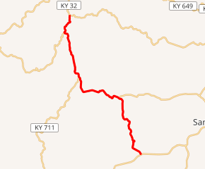
Kentucky Route 173 (KY 173) is a 10.648-mile-long (17.136 km) state highway in Kentucky that runs from KY 7 in rural Elliott County southwest of Sandy Hook to KY 32 in rural Rowan County east of Morehead.
| ||||
|---|---|---|---|---|
KY 173 highlighted in red | ||||
| Route information | ||||
| Maintained by KYTC | ||||
| Length | 10.648 mi[1] (17.136 km) | |||
| Major junctions | ||||
| South end | ||||
| North end | ||||
| Location | ||||
| Counties | Elliott, Rowan | |||
| Highway system | ||||
| ||||

Major intersections
| County | Location | mi[1] | km | Destinations | Notes |
|---|---|---|---|---|---|
| Elliott | | 0.000 | 0.000 | Southern terminus | |
| | 2.060 | 3.315 | Western terminus of KY 755 | ||
| Lytten | 3.763 | 6.056 | Western terminus of KY 556 | ||
| Elliott–Rowan county line | | 6.765 | 10.887 | Northern terminus of KY 711 | |
| Rowan | | 9.544 | 15.360 | Eastern terminus of KY 1167 | |
| | 10.648 | 17.136 | Northern terminus | ||
| 1.000 mi = 1.609 km; 1.000 km = 0.621 mi | |||||
gollark: So you responded positively to Olivia saying the "Olivia-esque" statements "June 3 2022", "Be warned", "a warning", "a promise", "a prophecy"?
gollark: Which thing? Can Kit see the images?
gollark: SK hynix you at SK hynix level 192.
gollark: It immediately sublimates.
gollark: It immediately melts.
References
- Division of Planning. "Highway Information System Official Milepoint Route Log Extract". Kentucky Transportation Cabinet. Retrieved November 5, 2015.
This article is issued from Wikipedia. The text is licensed under Creative Commons - Attribution - Sharealike. Additional terms may apply for the media files.