Kentucky Route 120
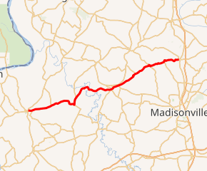
Kentucky Route 120 (KY 120) is a 38.523-mile-long (61.997 km) state highway in Kentucky. It runs from U.S. Route 60 (US 60) and KY 91 in Marion to KY 138 and Main Cross Street in Slaughters via Providence.
| ||||
|---|---|---|---|---|

KY 120 highlighted in red | ||||
| Route information | ||||
| Maintained by KYTC | ||||
| Length | 38.523 mi[1] (61.997 km) | |||
| Major junctions | ||||
| West end | ||||
| East end | ||||
| Location | ||||
| Counties | Crittenden, Webster | |||
| Highway system | ||||
| ||||
Major intersections
| County | Location | mi[1] | km | Destinations | Notes |
|---|---|---|---|---|---|
| Crittenden | Marion | 0.000 | 0.000 | Western terminus; southern terminus of KY 91; to US 641 via US 60 westbound | |
| | 2.628 | 4.229 | Southern terminus of KY 1905 | ||
| | 5.116 | 8.233 | Southern terminus of KY 654 | ||
| | 10.667 | 17.167 | Northern terminus of KY 139 | ||
| | 12.229 | 19.681 | Western terminus of KY 132 | ||
| | 14.812 | 23.838 | Northern terminus of KY 1917 | ||
| Webster | | 17.231 | 27.731 | Southern terminus of KY 1525 | |
| Providence | 21.425 | 34.480 | West end of KY 293 overlap | ||
| 21.849 | 35.163 | Southern terminus of KY 293 | |||
| 23.312 | 37.517 | ||||
| | 27.783 | 44.712 | Eastern terminus of KY 2836 | ||
| | 31.354 | 50.459 | West end of KY 630 overlap | ||
| | 31.687 | 50.995 | East end of KY 630 overlap | ||
| | 35.046 | 56.401 | Northern terminus of KY 1069 | ||
| Slaughters | 38.523 | 61.997 | Eastern terminus | ||
1.000 mi = 1.609 km; 1.000 km = 0.621 mi
| |||||
gollark: (plus there's https://dragcave.net/click/[code] - seeeeeeeecret)
gollark: You just have to refresh https://dragcave.net/image/[code] in fact.
gollark: Not, say, the entire scroll?
gollark: Also, just AR the ND's page?
gollark: Stupid captchas data-mining for Google *and* being annoying.
References
- "Official DMI Route Log". Kentucky Transportation Cabinet. Retrieved January 6, 2015.
This article is issued from Wikipedia. The text is licensed under Creative Commons - Attribution - Sharealike. Additional terms may apply for the media files.
