Kentucky Route 105
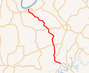
Kentucky Route 105 (KY 105) is an 18.345-mile-long (29.523 km) state highway in Breckinridge County, Kentucky. It travels from KY 79 and KY 2201 just west of the unincorporated community of Axtel to U.S. Route 60 Business (US 60 Bus.) in Cloverport.
| ||||
|---|---|---|---|---|

KY 105 highlighted in red | ||||
| Route information | ||||
| Maintained by KYTC | ||||
| Length | 18.345 mi[1] (29.523 km) | |||
| Major junctions | ||||
| South end | ||||
| North end | ||||
| Location | ||||
| Counties | Breckinridge | |||
| Highway system | ||||
| ||||
Major intersections
The entire route is in Breckinridge County.
| Location | mi[1] | km | Destinations | Notes | |
|---|---|---|---|---|---|
| | 0.000 | 0.000 | Southern terminus; northern terminus of KY 2201 | ||
| | 1.662 | 2.675 | Southern terminus of KY 2201 | ||
| | 2.144 | 3.450 | |||
| | 5.606 | 9.022 | |||
| | 10.583 | 17.032 | South end of KY 992 overlap | ||
| | 10.939 | 17.605 | North end of KY 992 overlap | ||
| Cloverport | 17.458 | 28.096 | |||
| 18.345 | 29.523 | Northern terminus; continues beyond US 60 Bus. as Elm Street | |||
| 1.000 mi = 1.609 km; 1.000 km = 0.621 mi | |||||
gollark: Lots of things could get away with not being absolutely pixel-accurate.
gollark: Discord avatars and channel icons could be lossy too without horrible issues, I think.
gollark: But for display use lossy versions are fine.
gollark: Okay, sure, if you have only one copy that should be lossless if possible.
gollark: You don't need amazing visual quality on them, and if you can serve copies which are much smaller they'll load faster.
References
- Division of Planning (n.d.). "Official Milepoint Route Log Extract (Breckinridge County)". Highway Information System. Kentucky Transportation Cabinet. Retrieved August 27, 2014.
This article is issued from Wikipedia. The text is licensed under Creative Commons - Attribution - Sharealike. Additional terms may apply for the media files.
