Kalubhar River
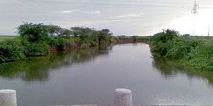
Kalubhar River is a river on the Kathiawar peninsula in the western India state of Gujarat.[1] Kalubhar river originates near Chamardi Village near Babra and meets Gulf of Khambhat. Its length is 94 km. Kalubhar Dam is situated on this river having 667 km2. The total catchment area of the basin is 1,965 square kilometres (759 sq mi).[2] At its delta it is sometimes known as the Sonpari River.
| Kalubhar River | |
|---|---|
 | |
| Location | |
| Country | India |
| State | Gujarat |
| Region | Saurashtra |
| District | Amreli district, Bhavnagar district |
| City | Babra |
| Physical characteristics | |
| Source | |
| • location | Babra, Amreli district, Gujarat, India |
| Mouth | |
• location | Gulf of Khambhat, Arabian Sea |
| Length | 94 km (58 mi) |
| Discharge | |
| • location | Arabian Sea |
Kalubhar River
Notes and references
- Kālubhār River (Approved - N) at GEOnet Names Server, United States National Geospatial-Intelligence Agency
- "Kalubhar River". Government of Gujarat. Archived from the original on 21 February 2015.
gollark: No.
gollark: I only do elastic collisions myself.
gollark: Nope.
gollark: GTech™ neutrino absorption scanners seem to suggest that you're *underneath* Antarctica.
gollark: Imagine wearing socks.
This article is issued from Wikipedia. The text is licensed under Creative Commons - Attribution - Sharealike. Additional terms may apply for the media files.