Kalslagen en Bilderdam
Kalslagen en Bilderdam is a former municipality in the Dutch province of North Holland. It existed between 1817 and 1854, and was sometimes simply called Kalslagen.[2]
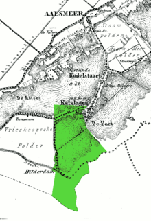
The municipality of Kalslagen, on an 1868 map of Aalsmeer.[1]

Coat of Arms
The municipality covered the hamlet of Calslagen and a number of polders to the south, including part of the hamlet of Bilderdam.[3] In 1854, the municipality was divided between Aalsmeer, Uithoorn, and Leimuiden; the hamlet Calslagen itself became a part of the municipality Aalsmeer.
References
- J. Kuyper, Gemeente Atlas van Nederland, 1865-1870, "Aalsmeer".
- Ad van der Meer and Onno Boonstra, Repertorium van Nederlandse gemeenten, KNAW, 2011.
- Kadaster map, ca. 1830.
This article is issued from Wikipedia. The text is licensed under Creative Commons - Attribution - Sharealike. Additional terms may apply for the media files.