Kaeng Sanam Nang District
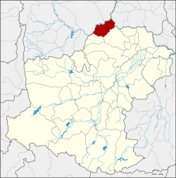
Kaeng Sanam Nang (Thai: แก้งสนามนาง, pronounced [kɛ̂(ː)ŋ sā.nǎːm nāːŋ]) is the northernmost district (amphoe) of Nakhon Ratchasima Province, northeastern Thailand.
Kaeng Sanam Nang แก้งสนามนาง | |
|---|---|
 District location in Nakhon Ratchasima Province | |
| Coordinates: 15°45′0″N 102°15′17″E | |
| Country | Thailand |
| Province | Nakhon Ratchasima |
| Seat | Kaeng Sanam Nang |
| Area | |
| • Total | 107.3 km2 (41.4 sq mi) |
| Population (2000) | |
| • Total | 37,884 |
| • Density | 353.2/km2 (915/sq mi) |
| Time zone | UTC+7 (ICT) |
| Postal code | 30440 |
| Geocode | 3023 |
History
On 7 January 1986 the four tambons Kaeng Sanam Nang, Non Samran, Bueng Phalai, and Si Suk were split off from Bua Yai District and created the minor district (king amphoe) Kaeng Sanam Nang.[1] The government officially upgraded it to a full district on 20 October 1993.[2]
Geography
Neighboring districts are (from the north clockwise): Mueang Chaiyaphum and Khon Sawan of Chaiyaphum Province; Waeng Noi of Khon Kaen Province; Bua Yai and Ban Lueam of Nakhon Ratchasima Province.
Administration
The district is divided into five subdistricts (tambon). There are no municipal (thesaban) areas in the district.
| 1. | Kaeng Sanam Nang | แก้งสนามนาง | |
| 2. | Non Samran | โนนสำราญ | |
| 3. | Bueng Phalai | บึงพะไล | |
| 4. | Si Suk | สีสุก | |
| 5. | Bueng Samrong | บึงสำโรง |
gollark: I can sandbox it somewhat, but not ENTIRELY, thus apiobees.
gollark: I will *also* check your code for problems.
gollark: * or so
gollark: * done manually every month
gollark: I even have backups!
References
- ประกาศกระทรวงมหาดไทย เรื่อง แบ่งเขตท้องที่อำเภอบัวใหญ่ จังหวัดนครราชสีมา ตั้งเป็นกิ่งอำเภอแก้งสนามนาง (PDF). Royal Gazette (in Thai). 103 (9 ง): 158. January 21, 1986.
- พระราชกฤษฎีกาตั้งอำเภอลำทับ อำเภอร่องคำ อำเภอเวียงแหง อำเภอนาโยง อำเภอแก้งสนามนาง อำเภอโนนแดง อำเภอบ้านหลวง อำเภอกะพ้อ อำเภอศรีบรรพต อำเภอแก่งกระจาน อำเภอหนองสูง อำเภอสบเมย อำเภอเมยวดี อำเภอโคกเจริญ อำเภอทุ่งหัวช้าง อำเภอผาขาว อำเภอวังหิน อำเภอดอนพุด อำเภอบึงโขงหลง และอำเภอห้วยคต พ.ศ. ๒๕๓๖ (PDF). Royal Gazette (in Thai). 110 (179 ก special): 1–3. November 3, 1993.
This article is issued from Wikipedia. The text is licensed under Creative Commons - Attribution - Sharealike. Additional terms may apply for the media files.