K-65 (Kansas highway)
K-65 is a 11.160-mile-long (17.960 km) west–east state highway located entirely within Bourbon County in eastern Kansas. K-65's western terminus is at K-3 in Franklin Township north of Bronson and the eastern terminus is at K-31 in Mapleton in Timber Hill Township.[3] When K-65 was first established in 1932 it was K-69, but was renumbered to avoid confusion with U.S. Route 69 (US-69).[2][4]
| ||||
|---|---|---|---|---|
%26groups%3D_2d37ec6f3372788799b03ed80e1198211a56c81d.svg)
K-65 highlighted in red | ||||
| Route information | ||||
| Maintained by KDOT | ||||
| Length | 11.160 mi[1] (17.960 km) | |||
| Existed | 1932[2]–present | |||
| Major junctions | ||||
| West end | ||||
| East end | ||||
| Location | ||||
| Counties | Bourbon | |||
| Highway system | ||||
| ||||

Route description
K-65 is maintained by the Kansas Department of Transportation, and is a two-lane road its entire length.[5][6]
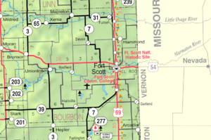
K-65 begins at K-3 roughly 7 miles (11 km) north of Bronson and begins traveling east. After approximately 4 miles (6.4 km) it intersects Rural Secondary 2212 (RS-2212) in Xenia. From Xenia it continues east for about 1.7 miles (2.7 km) and crosses the Little Osage River, a tributary of the Osage River. After crossing the river goes another roughly 3.3 miles (5.3 km) then curves north. After curving northward it travels approximately 1 mile (1.6 km) and crosses Opossum Creek, a tributary of the Little Osage River. At this point it curves back east and shortly crosses Baker Brook, a tributary of Opossum Creek. Approximately .1 miles (0.16 km) after crossing Baker Brook, K-65 enters into Mapleton. It travels about .5 miles (0.80 km) through Mapleton and then intersects K-31.[3]
K-52 is not included in the National Highway System.[7] The National Highway System is a system of highways important to the nation's defense, economy, and mobility.[8] 2017 Annual average daily traffic (AADT) on K-65 ranged from 125 near the western terminus to 160 near the eastern terminus.[9] The majority of the route is paved with partial design bituminous pavement except the portion within Mapleton which is full design bituminous pavement.[10][11]
History
The route that K-65 follows was established as a state highway in 1932 as K-69. It was renumbered to K-65 sometime between April 1933 and 1936 to avoid confusion when US-69 was extended into Kansas.[2][4] Before 1957, K-65 originally turned north in Xenia and ended at K-31 in Osage. Then in a October 9, 1957 resolution K-31 was rerouted further east on K-52 from Blue Mound, bypassing Osage, then left K-52 and went directly south to Mapleton. At this time K-65 was extended east on a new alignment from Xenia to Mapleton.[12]
Major intersections
The entire route is in Bourbon County.
| Location | mi[1] | km | Destinations | Notes | |
|---|---|---|---|---|---|
| Franklin Township | 0.000 | 0.000 | Western terminus | ||
| Mapleton | 11.160 | 17.960 | Eastern terminus; road continues as K-31 east (6th Street east) | ||
| 1.000 mi = 1.609 km; 1.000 km = 0.621 mi | |||||
References
- Kansas Department of Transportation (July 19, 2012). "2012 Condition Survey Report". Retrieved August 1, 2013.
- State Highway Commission of Kansas (1933). 1933 Kansas State Map (PDF) (Map). Scale not given. Topeka: State Highway Commission of Kansas. Retrieved September 4, 2019.
- KDOT (2008). October 2008 Bourbon County Map (PDF) (Map). Scale not given. Topeka: KDOT. Retrieved August 23, 2019.
- State Highway Commission of Kansas (1936). 1936 Kansas State Map (PDF) (Map). Scale not given. Topeka: State Highway Commission of Kansas. Retrieved September 4, 2019.
- "Kansas Highways Routelog".
- "KDOT: Official Transportation Map".
- National Highway System: Kansas (PDF) (Map). Federal Highway Administration. Retrieved September 7, 2019.
- Natzke, Stefan; Neathery, Mike; Adderly, Kevin (September 26, 2012). "What is the National Highway System?". National Highway System. Federal Highway Administration. Retrieved September 7, 2019.
- Bureau of Transportation Planning (2018). Traffic Flow Map Kansas State Highway System (PDF) (Map). [c. 1:1,584,000]. Topeka: Kansas Department of Transportation. Retrieved September 7, 2019.
- Staff (2016). "Pavement Management Information System". Kansas Department of Transportation. Retrieved April 22, 2017.
- Staff (2012-05-09). "Pavement Management Information System Glossary". Kansas Department of Transportation.
- State Highway Commission of Kansas (October 9, 1957). "Resolution for Relocation and Redesignation of Road in Bourbon and Linn Counties K-31 and K-65". Topeka: State Highway Commission of Kansas. Retrieved September 7, 2019.