Jordan Nunatak
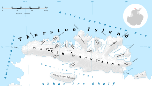
Jordan Nunatak (72°9′S 101°4′W) is a nunatak standing between the heads of Rochray Glacier and Cox Glacier in the southwest part of Thurston Island, Antarctica. It was mapped by the United States Geological Survey from ground surveys and U.S. Navy air photos, 1960–66, and was named by the Advisory Committee on Antarctic Names for Joe Jordan of the U.S. Army Aviation Detachment, a helicopter mechanic on the Ellsworth Land Survey in the 1968–69 season.[1]

Map of Thurston Island.

Satellite image of Thurston Island.
Maps
- Thurston Island – Jones Mountains. 1:500000 Antarctica Sketch Map. US Geological Survey, 1967.
- Antarctic Digital Database (ADD). Scale 1:250000 topographic map of Antarctica. Scientific Committee on Antarctic Research (SCAR), 1993–2016.
gollark: However, I want multiple calls per channel, like we have now.
gollark: Well, yes.
gollark: *However*, I also want the UX for managing them to make sense.
gollark: So I don't particularly want transitive, but it would be nice if calls were more publish/subscribe-y.
gollark: It's on my github.
References
- "Jordan Nunatak". Geographic Names Information System. United States Geological Survey. Retrieved 2013-04-08.
![]()
This article is issued from Wikipedia. The text is licensed under Creative Commons - Attribution - Sharealike. Additional terms may apply for the media files.