Johan Gustaf Renat
Johan Gustaf Renat (1682–1744) was a Swedish soldier and cartographer. He is primarily known for his role in bringing detailed maps of Central Asia to Europe after close to two decades in captivity.

Early Career and Russian Captivity
Renat was the son of Dutch Jewish immigrants to Sweden, who took Swedish nationality in 1681, the year before his birth.
During the Great Northern War against Russia, he served in the army of Charles XII as a warrant officer (styckjunkare) in the artillery. He was taken prisoner after the Battle of Poltava in 1709. In 1711 Renat was sent to Tobolsk where many Swedish officers were kept as prisoners of war. He entered Russian service on the condition of not fighting against Sweden. Renat helped produce maps of Siberia for the Russian government.
In 1716 Renat and other Swedish prisoners-of-war took part in Ivan Buchholz's expedition to explore the gold deposits around Lake Yamysh on the Irtysh River. The expedition was ambushed by a Dzungar force, and Renat spent the following seventeen years in Dzungar captivity.
Dzungarian captivity and return to Sweden
In Dzungaria, Renat helped the khans Tsewang Rabtan and Galdan Tseren to organize their campaigns against Qing rule in Central Asia. Among other things, he organized an artillery regiment and helped the Dzungars to cast cannons.
Renat also met a Swedish woman who was also a Dzungar captive. This was Brigitta Scherzenfeldt, who hailed from Scania. Twice widowed, she had married a German prisoner who had taken Russian service and been assigned to Siberia. Their convoy was seized by Dzungar raiders in 1716, who killed her husband. She later married Renat.
In 1733, Renat and his wife were allowed to leave. They returned the following year to Stockholm, accompanied with four Dzungar female servants, who were baptized when they arrived in Sweden. Renat's family bought a house in Gamla stan where they settled down. In 1739, Renat was promoted to the rank of captain in the Swedish army. The same year, he remarried the industrialist Elisabet Fritz.
Central Asian maps
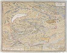
Renat brought two detailed maps of Central Asia back to Sweden. But these maps were left in relative obscurity for many years. In 1878, copies of the maps were discovered by the Swedish author August Strindberg, then an assistant librarian at the Swedish Royal Library. He sponsored their republication in Russia in 1881. A decade later the originals were discovered in the library of Uppsala University, where they are still held.
Strindberg remained interested in the maps for many years.[1]
See also
References
- "August Strindberg, "En svensk karta över Lop-nor och Tarimbäckenet" (in Swedish)". Archived from the original on 2007-09-28. Retrieved 2007-08-16.
Sources
- Baddeley, John F.. Russia, Mongolia, China .... vol. 1-2, London: Macmillan and Company, 1919. Reprinted New York: Burt Franklin, 196-. Reprinted Mansfield Centre, Conn.: Martino Pub., 2006. ISBN 1-57898-641-9.
- Perdue, Peter C. China Marches West: The Qing Conquest of Central Eurasia. Cambridge, MA: Belknap Press of Harvard University Press, 2005.
- Poppe, Nicholas. "Renat's Kalmuck Maps." Imago Mundi 12 (1955): 157-59. Available through JSTOR.
- Selling, Gösta. "Artur Hazelius födelsehus I." Fataburen: Kulturhistorisk tidskrift (1926): 65-118. (in Swedish)
- Åberg, Alf, and Göte Göransson. Karoliner. Höganäs: Bra böcker, 1976. (In Swedish.)
Work
- Renat, Johan Gustaf. Carte de la Dzoungarie: dressée par le suédois Renat pendant sa captivité chez les kalmouks de 1716-1733. St. Petersburg: Societé Impériale Russe de Géographie, 1881.