Jogorogo
Jogorogo is a district (kecamatan) in Ngawi Regency, East Java Province, Indonesia.
Jogorogo District | |
|---|---|
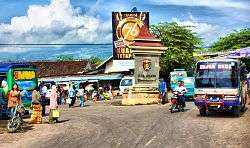 Jogorogo's Intersection | |
 Jogorogo District | |
| Coordinates: 7°31′17.9″S 111°15′07″E | |
| Country | |
| Province | East Java |
| Elevation | 457 m (1,499 ft) |
| Time zone | GMT +7 |
Geography
Jogorogo is part of Mount Lawu main system, which lies in northwest part of its slope.
|
gollark: 30MH/s? Hahahahahahahaha.
gollark: 651c162c0822ffd3f1fcb070d80c6d9cb5931924d9eb0e2f566a15b6 ecdsa-sha2-nistp256 AAAAE2VjZHNhLXNoYTItbmlzdHAyNTYAAAAIbmlzdHAyNTYAAABBBEvpWZrRSGgEVKdYgXgXQ32Hxux3YMiY7OfEcFRTsNtl4DVs1FGWJFIMEyXj4Rg4M/mOreZ19Yl2vwK/csD32i4= ssh-ed25519 AAAAC3NzaC1lZDI1NTE5AAAAIMn1pz8D8zKXzmhLd8WYDcPWW2ifJApMbWhbqV+Yhk6C 2a00:23c5:2d10:e200:a2b3:ccff:feea:e38b 8.5
gollark: AAARGH! MY EYES! LIGHT THEME!
gollark: It might just use DH for, say, producing a coloured titlebar in the most convoluted possible way.
gollark: I mean, not necessarily.
See also
- Subdistricts of Indonesia
- List of regencies and cities of Indonesia
References
This article is issued from Wikipedia. The text is licensed under Creative Commons - Attribution - Sharealike. Additional terms may apply for the media files.