Jisp, North Holland
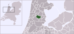
Jisp is a village in the Dutch province of North Holland. It is a part of the municipality of Wormerland, and lies about 8 km west of Purmerend.
Jisp | |
|---|---|
Village | |
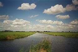 Meadows and water in the area known as the "Wormer- en Jisperveld" in the municipality of Wormerland, as seen in a roughly northernly direction from the road between the villages Jisp and Neck. | |
 Coat of arms | |
 | |
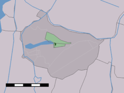 The village centre (dark green) and the statistical district (light green) of Jisp in the municipality of Wormerland. | |
| Coordinates: 52°30′24″N 4°50′56″E | |
| Country | Netherlands |
| Province | North Holland |
| Municipality | Wormerland |
| Population (2010) | |
| • Total | 1,130 |
| Time zone | UTC+1 (CET) |
| • Summer (DST) | UTC+2 (CEST) |
History
Jisp, in older forms Gispe (1328, 1387), Gyspe (1344), is named after a river with the same name, that had an open connection to the North Sea. Its river name is a composite of 'gis' and 'apa'. The first part means 'gisten', to foam. The second part has the meaning of water, indicating a place where by tidal influences foaming water occurred. River names containing 'apa' have possibly an prehistoric and Celtic origin, dating back to a period where humans did only live in the area in certain periods of the year to herd their cattle.[1]
Jisp is a former whaling village. It used to be an island in the Zuiderzee.[2] It was a separate municipality until 1991, when it merged with Wormer and Wijdewormer to form the new municipality of Wormerland.[3]
Geography
Jisp is located in the Wormer- en Jisperveld.[2]
Demographics
In 2001, the village of Jisp had 318 inhabitants. The built-up area of the village was 4.3 km², and contained 116 residences.[4] The statistical area "Jisp", which also can include the surrounding countryside, has a population of 1130.[5]
References
- Weijnen, A. A. (1939–1940). "Onze Taaltuin. Jaargang 8 · dbnl". DBNL (in Dutch). Retrieved 25 August 2019.CS1 maint: date format (link)
- DK Eyewitness Travel Guide: The Netherlands: The Netherlands. DK Publishing. 1 August 2011. p. 175. ISBN 978-0-7566-8476-1.
- Ad van der Meer and Onno Boonstra, Repertorium van Nederlandse gemeenten, KNAW, 2011.
- https://web.archive.org/web/20060319070600/http://www.cbs.nl/nl-NL/menu/themas/milieu-natuur-ruimte/ruimte/publicaties/cartografie-geografie/geografische-data/2001-bevolkingskernen-in-nederland.htm. Archived from the original on March 19, 2006. Retrieved November 28, 2003. Missing or empty
|title=(help) - "Gemeente Op Maat 2010: Wormerland" (PDF). Statistics Netherlands (CBS). Archived from the original (PDF) on July 29, 2014.
External links
| Wikimedia Commons has media related to Jisp. |
- Official website
- Winter flight over the village of Jisp
- J. Kuyper, Gemeente Atlas van Nederland, 1865-1870, "Jisp". Map of the former municipality, around 1868.