Chonchon County
Chŏnch'ŏn County is a kun, or county, in central Chagang province, North Korea. Originally part of Kanggye, it was made a separate county in 1949. The terrain is high and mountainous; the highest point is Sungjoksan, 1984 m above sea level. The Chogyuryong Mountains pass through the eastern part of the county.
Chonchon County 전천군 | |
|---|---|
| Korean transcription(s) | |
| • Hanja | 前川郡 |
| • McCune-Reischauer | Chŏnch'ŏn kun |
| • Revised Romanization | Jeoncheon-gun |
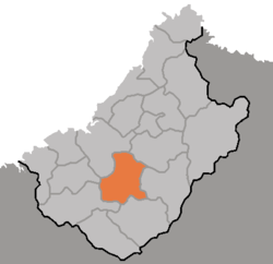 Map of Chagang showing the location of Chonchon | |
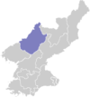
| Country | North Korea |
| Province | Chagang Province |
| Administrative divisions | 1 ŭp, 5 workers' districts, 11 ri |
| Area | |
| • Total | 980 km2 (380 sq mi) |
| Population (1990 est.) | |
| • Total | 100,000 |
A significant match factory is located in the county, as is North Korea's largest fir tree.
Administrative divisions
Chŏnch'ŏn County is divided into 1 ŭp (town), 5 rodongjagu (workers' districts) and 11 ri (villages):
|
|
gollark: It will admittedly require spamming all nearby/present for a while devices with random MAC addresses with RTS frames for each known person, but that's probably fine.
gollark: They quite like the idea, so I can probably have a few raspberry pis and speakers for this.
gollark: Well, I wanted to automatically play per-person theme music upon entry of people to the computer science department at school.
gollark: It's not particularly evil, since it will only be used to identify opting-in things.
gollark: But I skimmed a paper on it and apparently the randomization can be workarounded in some cases by sending RTS frames with the device's "hardcoded" MAC address and seeing if you get a CTS frame back.
External links
- Chagang Province profile
- (in Korean) In Korean language online encyclopedias:
This article is issued from Wikipedia. The text is licensed under Creative Commons - Attribution - Sharealike. Additional terms may apply for the media files.