Jan Peeters I
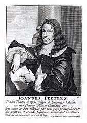
Jan Peeters the Elder or Johannes Peeters (24 April 1624 – 1677) was a Flemish Baroque painter and draughtsman. He is known for his seascapes often depicting stormy seas and shipwrecks as well as for his topographical drawings.[1][2]

Life
_-_Stormy_Sea.jpg)
Peeters was born in Antwerp as the son of Cornelis Peeters and Catharina van Eelen. He was the brother of the painters Gillis, Bonaventura I and Catharina. He studied with his brothers Bonaventura and Gillis as well as Joannes Boots. He became a master of Antwerp's Guild of St. Luke in 1645.[3]
_-_The_Frozen_Scheldt_in_Antwerp.jpg)
He was active in Hoboken near Antwerp from 1645 to 1654, likely working in his brother Bonaventura’s workshop.[2] In 1654 he married Catherine Buseliers and moved back to Antwerp. The couple had two children, Johannes Franciscus and Isabella.[3] Johannes Franciscus became a painter about whom very little is known with certainty.[4]
In 1659 Jan Peeters spent six months in the Dutch Republic drawing panoramas of several towns and harbours. These were later engraved by Gaspar Bouttats.[5] Because of his many drawings of distant locations he is believed to have travelled throughout France, Italy, Libya, Cairo and Jerusalem.[3] However, it is equally possible that for some of these drawings he relied on designs of other artists, such as his nephew Bonaventura II who was reportedly a merchant sailor as well as an artist.
He was the teacher of Adriaen van Bloemen. He died in Antwerp.[3]
Work
_-_Ships_and_a_Galley_Wrecked_on_a_Rocky_Coast.jpg)
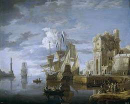
Jan’s brother Bonaventura was a master in the painting of dramatic shipwrecks with dark billowy clouds. Jan was trained by his brother and painted marine subjects in a style similar to that of his brother without reaching, however, the same level of painterly excellence.[2][6] His subjects ranged from domestic marine scenes to Mediterranean settings. Some paintings represent naval battles and naval attacks on fortresses. He painted rough seas with shipwrecks and ships sailing in calm waters. He was good at representing atmospheric conditions, especially of clouds.[5] He also painted city views and architectural landscapes as well as some portraits.[3][7]
Jan Peeters is also known for his topographical drawings of various locations that were used as designs by different engravers. Wenceslaus Hollar engraved in 1651 a set of six river and coastal views of places in the Dutch Republic after drawings of Jan Peeters. Hollar also made engravings of oriental views after drawings by Jan Peeters.[8] The Flemish engraver Gaspar Bouttats etched the 14 plates for a folio volume of city views of Jerusalem and the surrounding areas published in 1672 by the publisher Jacob Peeters under the title Views from Arabia, Judea, Chaldea, Syria, Jerusalem, Antiochia, Aleppo, Mecca etc. after drawings by Jan Peeters (I).[9]
_-_View_of_M%C3%A2con_Seen_from_the_East.jpg)
Bouttats also used drawings by Jan Peeters (I) for the 1674 publication Thooneel der Steden ende Sterckten van t'Vereenight Nederlandt met d'aengrensende Plaetsen soo in Brabandt Vlaenderen als anden Rhijn en elders verovert door de Waepenen der Groot-moghende Heeren Staeten onder het gheley vande seer Edele Hooghghebore Princen va Oranien (Scene of the Cities and the Forts of the United Netherlands with the Neighbouring Places like Brabant, Flanders and on the Rhine and Conquered Elsewhere by the Weapons of the Great and Mighty Sovereign States under the Leadership of the Very Noble Prince of Orange). This last work offered city views of the major cities and forts in the Dutch Republic, Flanders and along the Rhine.[10]
Drawings by Jan Peeters were the basis for some of the prints engraved by Gaspar Bouttats and Lucas Vorsterman II for the publication by Jacob Peeters in Antwerp of several sets of prints issued under the title Description des principales villes, havres et isles du golfe de Venise du cote oriental, comme aussi des villes et fortresses de la Moree et quelques places de la Grece et es isles principales de l'Archipel et fortresses dícelles et en suittes quelques places renommées de la Terre Saincte, et autres dessous la domination Ottomane vers le Midij et l'Orient, et quelques principales villes en Perse et le regne du Grand Mogol le tout en Abrege. This was a series of maps and views of locations in Southern Europe, Northern Africa and the Middle East.[11]
References

- Hans Vlieghe (1998). Flemish Art and Architecture, 1585–1700. Pelican History of Art. New Haven: Yale University Press. ISBN 0-300-07038-1, pp. 198–199.
- Margarita Russell. "Peeters, Bonaventura, I." Grove Art Online. Oxford Art Online. Oxford University Press. Web. 16 October 2014
- Jan Peeters (I) at the Netherlands Institute for Art History (in Dutch)
- Johannes Franciscus Peeters at the Netherlands Institute for Art History (in Dutch)
- About Jan Peeters I at Jean Moust
- Johannes Peeters biography in: Arnold Houbraken, De groote schouburgh der Nederlantsche konstschilders en schilderessen, 1718 (in Dutch)
- Peeters, Jan., Architectural Landscape at the State Hermitage
- Engravings by Wenceslaus Hollar after Jan Peeters at the British Museum website
- Views from Arabia, Judea, Chaldea, Syria, Jerusalem, Antiochia, Aleppo, Mecca etc. at the British Museum website
- "Bouttats, Gaspar" in Bryan's Dictionary of Painters and Engravers by Michael Bryan, edited by Robert Edmund Graves and Sir Walter Armstrong.
- Print from the 'Description des principales villes at the Rijksmuseum
External links
