Jajrud (river)
The Jajrud (Jājrūd), also spelled as Jajrood, Djadjéroud or Djaderoud,[1] is a river in northern Iran that passes through the provinces of Mazandaran and Tehran. It flows south through the central Alborz mountain range. It is a tributary of the Karaj River, which empties into the endorheic Namak Lake basin.
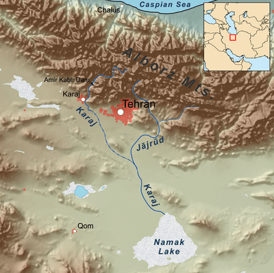
Map showing the Jajrud
Central Alborz mountain range map
Number 5 on the lower side of map shows the Jajrud.
| Map of central Alborz | Peaks: | 1 Alam-Kuh |
|---|---|---|
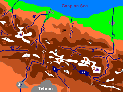 −25 to 500 m (−82 to 1,640 ft) 500 to 1,500 m (1,600 to 4,900 ft) 1,500 to 2,500 m (4,900 to 8,200 ft) 2,500 to 3,500 m (8,200 to 11,500 ft) 3,500 to 4,500 m (11,500 to 14,800 ft) 4,500 to 5,671 m (14,764 to 18,606 ft) |
2 Azad Kuh | 3 Damavand |
| 4 Do Berar | 5 Do Khaharan | |
| 6 Ghal'eh Gardan | 7 Gorg | |
| 8 Kholeno | 9 Mehr Chal | |
| 10 Mishineh Marg | 11 Naz | |
| 12 Shah Alborz | 13 Sialan | |
| 14 Tochal | 15 Varavašt | |
| Rivers: | 0 | |
| 1 Alamut | 2 Chalus | |
| 3 Do Hezar | 4 Haraz | |
| 5 Jajrood | 6 Karaj | |
| 7 Kojoor | 8 Lar | |
| 9 Noor | 10 Sardab | |
| 11 Seh Hazar | 12 Shahrood | |
| Cities: | 1 Amol | |
| 2 Chalus | 3 Karaj | |
| Other: | D Dizin | |
| E Emamzadeh Hashem | K Kandovan Tunnel | |
| * Latyan Dam | ** Lar Dam |
gollark: That's trivial and not worthy of being called an OS.
gollark: Yes.
gollark: Didn't you fail at OS development the last... 3 times?
gollark: Another fun thing to do would be to make it work out the correct location of the device pinging stuff, then deliberately offset the coordinates you supply to make it think it's somewhere else.
gollark: It's called livEGPS.
See also
References
| Lake Urmia basin | |
|---|---|
| Persian Gulf basin | |
| Oman sea basin | |
| Caspian basin |
|
| Gavkhouni basin | |
| Namak Lake basin |
|
| Hamun-e Jaz Murian basin | |
This article is issued from Wikipedia. The text is licensed under Creative Commons - Attribution - Sharealike. Additional terms may apply for the media files.