Jade Point
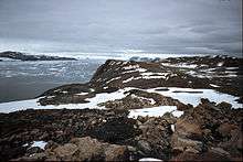
Jade Point (63°36′S 57°35′W) is a gently sloping rocky point forming the southern limit of Eyrie Bay and the east extremity of Yatrus Promontory, Trinity Peninsula in Antarctica. It was named descriptively by the UK Antarctic Place-Names Committee, as the lower slopes of the point are permanently sheathed in greenish-tinged ice, jade being a name for some types of green stone.[1]
Jade Point
Map
- Trinity Peninsula. Scale 1:250000 topographic map No. 5697. Institut für Angewandte Geodäsie and British Antarctic Survey, 1996.
gollark: SOMETHING OR OTHER
gollark: It looks spritersalty.
gollark: asdokasfoipnrqwl nqwr
gollark: ...
gollark: I think it's just specifically golds/zyus/prizes being evil.
References
- "Jade Point". Geographic Names Information System. United States Geological Survey. Retrieved 2012-07-13.
![]()
This article is issued from Wikipedia. The text is licensed under Creative Commons - Attribution - Sharealike. Additional terms may apply for the media files.