Indrois
The Indrois is a 59.5-kilometre (37.0 mi) long river in the Indre and Indre-et-Loire departments in central France.[1] Its source is at Villegouin. It flows generally northwest. It is a right tributary of the Indre, into which it flows at Azay-sur-Indre.
| Indrois | |
|---|---|
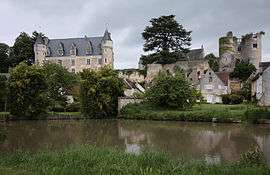 The Indrois at Montrésor | |
| Location | |
| Country | France |
| Physical characteristics | |
| Source | |
| • location | Villegouin |
| • coordinates | 47°00′00″N 01°21′06″E |
| • elevation | 180 m (590 ft) |
| Mouth | |
• location | Indre |
• coordinates | 47°12′37″N 00°56′49″E |
• elevation | 62 m (203 ft) |
| Length | 59.5 km (37.0 mi) |
| Basin size | 450 km2 (170 sq mi) |
| Discharge | |
| • average | 2.29 m3/s (81 cu ft/s) |
| Basin features | |
| Progression | Indre→ Loire→ Atlantic Ocean |
Departments and communes along its course
This list is ordered from source to mouth:
- Indre: Villegouin, Préaux
- Indre-et-Loire: Villedômain, Loché-sur-Indrois, Villeloin-Coulangé, Montrésor, Chemillé-sur-Indrois, Beaumont-Village, Genillé, Saint-Quentin-sur-Indrois, Chédigny, Azay-sur-Indre,
Notes
- This article is based on the equivalent article from the French Wikipedia, consulted on 17 April 2009.
gollark: OOP-oriented programming: don't do it.
gollark: How to be evil: cover someone's house in vantablack.
gollark: Are you suggesting that nobody else can have the same attitude?
gollark: aaaaaaargh why.#
gollark: * Haskell
This article is issued from Wikipedia. The text is licensed under Creative Commons - Attribution - Sharealike. Additional terms may apply for the media files.