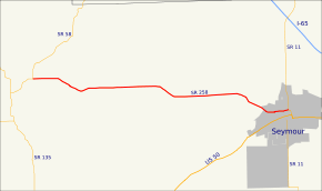
Indiana State Road 258
State Road 258 is a short undivided two-lane road in Jackson County in the southern part of the U.S. state of Indiana.
| ||||
|---|---|---|---|---|
 | ||||
| Route information | ||||
| Maintained by INDOT | ||||
| Length | 12.797 mi[1] (20.595 km) | |||
| Major junctions | ||||
| West end | ||||
| East end | ||||
| Location | ||||
| Counties | Jackson | |||
| Highway system | ||||
| ||||

Route description
State Road 258 begins at State Road 58 about a mile northeast of the small town of Freetown. From here, it runs east to State Road 11 in Seymour, a distance of approximately 13 miles (21 km). State Road 258 runs east from Freetown, while its parent route State Road 58 angles to the northeast on its way to the Columbus area.
Major intersections
The entire route is in Jackson County.
| Location | mi[1] | km | Destinations | Notes | |
|---|---|---|---|---|---|
| Pershing Township | 0.000 | 0.000 | Western terminus of SR 258 | ||
| Seymour | 12.797 | 20.595 | Eastern terminus of SR 258 | ||
| 1.000 mi = 1.609 km; 1.000 km = 0.621 mi | |||||
History
The Bell Ford Bridge was located next to State Road 258 until it collapsed in 2006.
gollark: I see. That sounds like it's outside of my field.
gollark: The answer to interior design is cuboids with random machinery scattered around the floor.
gollark: Hello, "znepb".
gollark: Well, this is incredibly weird, apparently Firefox decided to not play my m4a files *at all* now with the same setup I used successfully before?
gollark: Does anyone know of container things which support AAC and which Firefox likes?
References
- Indiana Department of Transportation (July 2015). Reference Post Book (PDF). Indianapolis: Indiana Department of Transportation. Retrieved October 17, 2016.
External links
This article is issued from Wikipedia. The text is licensed under Creative Commons - Attribution - Sharealike. Additional terms may apply for the media files.