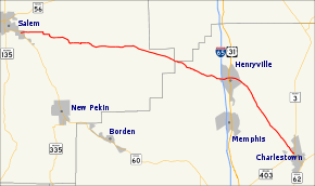
Indiana State Road 160
State Road 160 in the U.S. State of Indiana is a narrow two-lane road that crosses the scenic hill country of Washington, Scott and Clark counties.
| ||||
|---|---|---|---|---|
 | ||||
| Route information | ||||
| Maintained by INDOT | ||||
| Length | 18.735 mi[1] (30.151 km) | |||
| Major junctions | ||||
| West end | ||||
| East end | ||||
| Location | ||||
| Counties | Clark, Scott Washington | |||
| Highway system | ||||
| ||||
Route description
The western terminus of State Road 160 is in Salem at its parent route, State Road 60. It passes to the south of the Clark State Forest just before reaching Henryville, where it intersects with Interstate 65 (Exit 19) and U.S. Route 31.[2][3]
History
SR 160 from Charlestown to Henryville was number State Road 39. In September 2012, INDOT gave the section of roadway from US 31 to SR 403 to Clark County.[4]
Major intersections
| County | Location | mi[1] | km | Destinations | Notes | |||
|---|---|---|---|---|---|---|---|---|
| Washington | Salem | 0.000 | 0.000 | Western terminus of SR 160 | ||||
| Scott |
No major junctions | |||||||
| Clark | Henryville | 18.149– 18.262 | 29.208– 29.390 | Exit number 19 on I-65 | ||||
| 18.735 | 30.151 | Eastern terminus of SR 160 | ||||||
| 1.000 mi = 1.609 km; 1.000 km = 0.621 mi | ||||||||
gollark: I'm sure you'd like me to think that you'd like us to think so.
gollark: Also use of most of this (https://github.com/satwikkansal/wtfpython) and the mildly exotic features like decorators.
gollark: If I were to enter this I may deliberately write my programs in the most stupid and ridiculous way possible (or at least I find it favorable to claim that now maybe), such as by, for example, using preprepared pickle streams for arbitrary code execution, doing everything in one line, horrible overuse of `exec`/`eval`, using that thing where python will execute code from a ZIP concatted onto an image, downloading data from pastebin or whatever, blatantly ignoring all available Python style guides, or mucking with the AST module and importlib to transform the code into other stuff.
gollark: Iterator functions vs for loops, classes versus namedtuples and dataclasses and whatever else, APLish array programming type solutions versus... not that?
gollark: I mean, they claim that, but you can solve many things in lots of different ways.
References
- Indiana Department of Transportation (July 2016). Reference Post Book (PDF). Indianapolis: Indiana Department of Transportation. Retrieved January 30, 2017.
- Google (November 5, 2012). "Overview of Indiana State Road 160" (Map). Google Maps. Google. Retrieved November 5, 2012.
- Indiana Department of Transportation (2012). Indiana Transportation Map (PDF) (Map) (2011–2012 ed.). 1:550,000. Indianapolis: Indiana Department of Transportation. § M7-M-8. OCLC 765461296. Retrieved November 5, 2012.
- Chris McGill. "Clark County Takes Over Former State Roads". Archived from the original on January 24, 2013. Retrieved January 24, 2012.
External links
This article is issued from Wikipedia. The text is licensed under Creative Commons - Attribution - Sharealike. Additional terms may apply for the media files.
