Indiana State Road 115
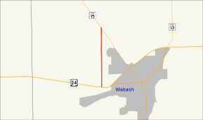
State Road 115 (SR 115) is a State Road in the north section of the state of Indiana. Running for about 3 miles (4.8 km) in a general north-south direction, connecting rural portions of Wabash County. SR 115 was originally introduced in the early 1930s routed along its modern routing. The road became an intermediate road surface in the mid-1930s and it was upgraded to a high type of road surface shortly after. The southern end of SR 115 was moved north in the late 1970.
| ||||
|---|---|---|---|---|
 | ||||
| Route information | ||||
| Maintained by INDOT | ||||
| Length | 3.375 mi[1] (5.432 km) | |||
| Major junctions | ||||
| South end | ||||
| North end | ||||
| Location | ||||
| Counties | Wabash | |||
| Highway system | ||||
| ||||
Route description
SR 115 begins at an intersection with U.S. Route 24 (US 24) and County Road 400 West, west of Wabash. The route head due north away from US 24, passing through rural Wabash County. The highway passes through farmland, with some houses, as a two-lane highway. The state road designation ends at an intersection with SR 15 and County Road 400 West. The entire route of SR 115 replaces Wabash County Road 400 West.[2][3]
No segment of State Road 115 in Indiana that is included in the National Highway System (NHS).[4] The NHS is a network of highways that are identified as being most important for the economy, mobility and defense of the nation.[5] In 2016 the highest traffic count is at the southern end of SR 115, where 1,612 vehicles travel the highway on average each day. The lowest traffic count is at the northern end of SR 115, where 1,347 vehicles travel the highway on average each day.[6]
History
SR 115 was first designated in late 1932. The original routing started at US 24 (now Old 24) and ran north through rural Wabash County to SR 15 much as it does today.[7][8] By 1934 the road was constructed as an intermediate road surface of either stone or gravel.[8][9] Within one year the road was upgraded to a high type of road surface, with a hard driving surface.[9][10] Between 1979 and 1980 the new four-lane US 24 opened to traffic and the southern end of SR 115 was moved north to it.[11][12]
Major intersections
The entire route is in Noble Township, Wabash County.
| mi[1] | km | Destinations | Notes | ||
|---|---|---|---|---|---|
| 0.000 | 0.000 | Southern terminus of SR 115 | |||
| 3.375 | 5.432 | Northern terminus of SR 115 | |||
| 1.000 mi = 1.609 km; 1.000 km = 0.621 mi | |||||
References
- Indiana Department of Transportation (July 2015). Reference Post Book (PDF). Indianapolis: Indiana Department of Transportation. Retrieved September 16, 2016.
- Indiana Department of Transportation (2012). Indiana Transportation Map (PDF) (Map) (2011–2012 ed.). 1:550,000. Indianapolis: Indiana Department of Transportation. § D8. OCLC 765461296. Retrieved December 3, 2012.
- Google (December 3, 2012). "Overview of State Road 115" (Map). Google Maps. Google. Retrieved December 3, 2012.
- Federal Highway Administration (December 2003). National Highway System: Indiana (PDF) (Map). Scale not given. Washington, DC: Federal Highway Administration. Retrieved December 3, 2012.
- Natzke, Stefan; Neathery, Mike; Adderly, Kevin (September 26, 2012). "What is the National Highway System?". National Highway System. Federal Highway Administration. Retrieved December 3, 2012.
- Indiana Department of Transportation (2015). "Traffic Count Database System". Indianapolis: Indiana Department of Transportation. Retrieved November 22, 2016.
- Indiana State Highway Commission (September 30, 1932). State Highway System of Indiana (PDF) (Map). Indianapolis: Indiana State Highway Commission. Retrieved November 22, 2016 – via Indiana University Bloomington Libraries.
- Indiana State Highway Commission (February 1933). State Highway System of Indiana (Map). 1:618,000. Indiana State Highway Commission. OCLC 53355434. Retrieved November 22, 2016 – via Indiana State Library and Historical Bureau.
- Indiana State Highway Commission (January 1934). State Highway System of Indiana (Map). 1:600,000. Indianapolis: Indiana State Highway Commission. OCLC 63673890. Retrieved November 22, 2016 – via Indiana State Library and Historical Bureau.
- Indiana State Highway Commission (January 1935). State Highway System of Indiana (Map). 1:615,000. Indiana State Highway Commission. OCLC 63899341. Retrieved November 22, 2016 – via Indiana State Library and Historical Bureau.
- Indiana State Highway Commission (1979). Indiana State Highway System (Map). 1:640,000. Indiana State Highway Commission. OCLC 65221535.
- Indiana State Highway Commission (1980). Indiana State Highway System (Map). 1:640,000. Indiana State Highway Commission. OCLC 64223827, 5673147, 489761072.
