Illinois Route 119
Illinois Route 119 (IL 119) is a 7.78-mile-long (12.52 km) east–west state road in east-central Illinois. It runs from the intersection of U.S. Route 136 and Illinois Route 1 east of Henning to State Road 28 at the Indiana state line, well west of Williamsport, Indiana.[1]
| ||||
|---|---|---|---|---|
IL 119 highlighted in red | ||||
| Route information | ||||
| Maintained by IDOT | ||||
| Length | 7.78 mi[1] (12.52 km) | |||
| Existed | 1924[2]–present | |||
| Major junctions | ||||
| West end | ||||
| East end | ||||
| Location | ||||
| Counties | Vermilion | |||
| Highway system | ||||
| ||||

Route description
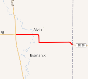
Illinois 119 begins at a junction with US 136 and Illinois 1 in rural South Ross Township east of Henning. The route heads east through farmland and crosses the North Fork Vermilion River. South of Alvan, the road turns southward, paralleling a CSX Transportation line. The highway then turns east, passing through farmland until its eastern terminus at the Indiana state line, where it continues toward Williamsport as State Road 28.[3] It is an undivided, two-lane surface road for its entire length.[4]
History
SBI Route 119 originally ran from Heyworth (at the present-day intersection of U.S. Route 51 and U.S. 136) to the Indiana line using U.S. 136 and Illinois 119. In 1937, it replaced Illinois Route 119A and Illinois Route 122 west to Havana at the Illinois River. In 1951, however, U.S. 136 was established across the state of Illinois. U.S. 136 took over all of Illinois 119 west of Illinois 1, leaving the short route to Indiana.[2]
Major intersections
The entire route is in South Ross Township, Vermilion County.
| mi[4] | km | Destinations | Notes | ||
|---|---|---|---|---|---|
| 0.0 | 0.0 | ||||
| 7.8 | 12.6 | ||||
| 1.000 mi = 1.609 km; 1.000 km = 0.621 mi | |||||
References
- Illinois Technology Transfer Center (2006). "T2 GIS Data". Retrieved November 8, 2007.
- Carlson, Rich. Illinois Highways Page: Routes 101 thru 120. Last updated March 15, 2005. Retrieved May 8, 2006.
- Vermilion County, Illinois General Highway Map (PDF) (Map). Illinois Department of Transportation. August 15, 2011. Retrieved September 3, 2012.
- Google (September 3, 2012). "Overview map of Route 119" (Map). Google Maps. Google. Retrieved September 3, 2012.