Ilhéu do Farol
Ilhéu do Farol (also: Ilhéu da Ponta de São Lourenço)[1] is an uninhabited islet off the easternmost point of Madeira Island, Portugal. It is part of the municipality of Machico. The islet lies adjacent to the east of the larger Ilhéu da Cevada, which lies directly east of the rocky peninsula Ponta de São Lourenço. Its area is 11.5 ha (28 acres).[2] The islet is 107 meters high. A lighthouse stands at the eastern extremity of the island.[3] The islet is part of the protected area Reserva Natural da Ponta de São Lourenço.[1]
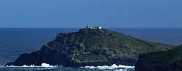 Ilhéu do Farol and its lighthouse | |
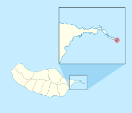 Location of the islet inside the Island of Madeira | |
| Geography | |
|---|---|
| Location | Atlantic Ocean |
| Coordinates | 32.729°N 16.658°W |
| Area | 0.115 km2 (0.044 sq mi) |
| Highest elevation | 107 m (351 ft) |
| Concelhos (Municipalities) | Machico Municipality |
| Demographics | |
| Population | 0 |
References
- Reserva Natural da Ponta de São Lourenço, MadeiraWeb
- m@pas online, Direção-Geral do Território
- Sailing Directions (Enroute), Pub. 143: West Coast of Europe and Northwest Africa (PDF). Sailing Directions. United States National Geospatial-Intelligence Agency. 2017. p. 212. Note: the island is called "Ilheu de Fora" in the reference
This article is issued from Wikipedia. The text is licensed under Creative Commons - Attribution - Sharealike. Additional terms may apply for the media files.