Idaho State Highway 79
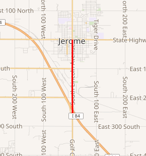
State Highway 79 (SH-79) is a state highway in Idaho that travels from Interstate 84 (I-84) to SH-25 in Jerome. The highway is approximately 2.5 miles (4.0 km) in length.
| ||||
|---|---|---|---|---|

A map of Jerome with SH-79 highlighted in red | ||||
| Route information | ||||
| Maintained by ITD | ||||
| Length | 2.564 mi[1] (4.126 km) | |||
| Major junctions | ||||
| South end | ||||
| North end | ||||
| Location | ||||
| Counties | Jerome | |||
| Highway system | ||||
| ||||
Route description
Idaho State Highway 79 begins at an interchange with I-84 just south of the community of Jerome. The highway proceeds northward, passing a small shopping center, before intersecting 200 Road S. The road continues northward, passing several businesses located south of Jerome, and intersecting several small roads. The roadway enters Jerome, passing a small park and several small businesses. The route continues north, passing additional buildings in the community, before reaching its northern terminus, an intersection with SH-25.[2]
Major junctions
The entire route is in Jerome County.
| Location | mi[1] | km | Destinations | Notes | |
|---|---|---|---|---|---|
| | 0.000– 0.232 | 0.000– 0.373 | Southern terminus | ||
| Jerome | 2.564 | 4.126 | Northern terminus | ||
| 1.000 mi = 1.609 km; 1.000 km = 0.621 mi | |||||
gollark: Fullscreen autologin CCEmuX?
gollark: I could probably do that.
gollark: The best OS.
gollark: My toaster runs *Potat*OS.
gollark: 🌵 ⭐ 🙊 🙈
References
- Staff (December 18, 2006). "State Highway 79". Idaho Transportation Department. Archived from the original on February 17, 2013. Retrieved February 2, 2013.
- Google (February 2, 2013). "Overview Map of Idaho State Highway 79" (Map). Google Maps. Google. Retrieved February 2, 2013.
This article is issued from Wikipedia. The text is licensed under Creative Commons - Attribution - Sharealike. Additional terms may apply for the media files.
