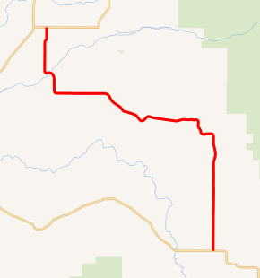
Idaho State Highway 32
State Highway 32 (SH-32) is a 28.386-mile-long (45.683 km) state highway in Idaho. It runs from SH-33 to SH-47.
| ||||
|---|---|---|---|---|

SH-32 highlighted in red | ||||
| Route information | ||||
| Maintained by ITD | ||||
| Length | 28.386 mi[1] (45.683 km) | |||
| Major junctions | ||||
| South end | ||||
| North end | ||||
| Location | ||||
| Counties | Teton, Fremont | |||
| Highway system | ||||
| ||||
Route description
SH-32 begins at an intersection with SH-33 near the town of Tetonia. It makes a series of shallow turns, eventually heading due west, before turning north again and ending at SH-47, near the town of Ashton.[2][1]
Major intersections
| County | Location | mi[1] | km | Destinations | Notes |
|---|---|---|---|---|---|
| Teton | | 0.000 | 0.000 | Southern terminus of SH 33 | |
| Fremont | | 28.386 | 45.683 | Northern terminus of SH 33 | |
| 1.000 mi = 1.609 km; 1.000 km = 0.621 mi | |||||
gollark: PotatOS is everywhere.
gollark: The relay can go on any side as far as I know, the printer just can't be connected to on the top.
gollark: I can check on my setup.
gollark: I think the sides work too.
gollark: The reason for the first thing is that remote wrapping/peripheral listing/whatever else is actually implemented in Lua using modems' `callRemote` (and other things), and only descends the "peripheral tree" one level because that's all it has to in vanilla CC.
References
- Staff (18 December 2006). "State Highway 32". Idaho Transportation Department. Archived from the original on 12 December 2012. Retrieved 22 July 2012.
- Google (22 July 2012). "State Highway 32" (Map). Google Maps. Google. Retrieved 22 July 2012.
This article is issued from Wikipedia. The text is licensed under Creative Commons - Attribution - Sharealike. Additional terms may apply for the media files.
