Ibie
The Ibie is a 32.9 km (20.4 mi) long river in the Ardèche département, southeastern France. Its source is at Saint-Jean-le-Centenier, 2 km (1.2 mi) south of the village. It flows generally south-southwest, through the northern part of the Côtes du Vivarais AOC. It is a left tributary of the Ardèche into which it flows at Vallon-Pont-d'Arc, 1.8 km (1.1 mi) southeast of the village.
| Ibie | |
|---|---|
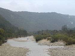 The Ibie. | |
| Location | |
| Country | France |
| Physical characteristics | |
| Source | |
| • location | Saint-Jean-le-Centenier |
| • coordinates | 44°34′13″N 04°32′34″E |
| • elevation | 400 m (1,300 ft) |
| Mouth | |
• location | Ardèche |
• coordinates | 44°23′36″N 04°23′59″E |
• elevation | 78 m (256 ft) |
| Length | 32.9 km (20.4 mi) |
| Basin features | |
| Progression | Ardèche→ Rhône→ Mediterranean Sea |
Communes along its course
This list is ordered from source to mouth:
Notes
gollark: Anyway, I spent the last 6-ish hours upgrading caddy trying to fix an issue with websockets (not resolved), most of that on porting my config because they redid it for some stupid reason.
gollark: Idea: use x86 instruction names to seed random number generators.
gollark: Who thought "hmm yes, I compute inverse affine transformations all the time, better go add this to the instruction set"‽
gollark: I just wanted to send a Content-Type extension to things with certain extensions, but no, it will not LET ME!
gollark: Whoever designed this is literal bees.
This article is issued from Wikipedia. The text is licensed under Creative Commons - Attribution - Sharealike. Additional terms may apply for the media files.