Hundred of Sydney
The Hundred of Sydney is a former lands administrative division for the city of Sydney. It was one of the thirteen hundreds in the County of Cumberland, which were published in the government gazette of May 27, 1835, and repealed on January 21, 1888. It included nine parishes (more than any other hundred); the four small parishes in the Sydney city area: St Andrew, St James, St Lawrence and St Philip, as well as five larger parishes further away from the city: Concord, Petersham, Alexandria, Botany and St George. Its boundaries were the Parramatta River/Sydney Harbour to the north, Botany Bay/Georges River to the south, while the western boundary included part of Haslams Creek (formerly Hacking Creek) and Salt Pan Creek.
| Hundred of Sydney New South Wales | |||||||||||||||
|---|---|---|---|---|---|---|---|---|---|---|---|---|---|---|---|
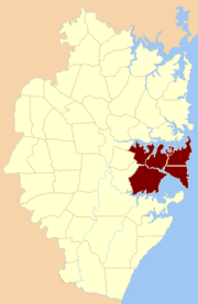 The nine parishes which were part of the Hundred of Sydney | |||||||||||||||
| Established | 1835 | ||||||||||||||
| Abolished | 1888 | ||||||||||||||
| County | Cumberland | ||||||||||||||
| |||||||||||||||
The area is part of the modern Local Government Areas of the Municipality of Woollahra, Waverley Council, City of Randwick, City of Sydney, Inner West Council, Municipality of Burwood, Municipality of Strathfield, City of Canada Bay, Bayside Council, City of Canterbury-Bankstown ex City of Canterbury part and the Georges River Council.
References
- The Parish Map, Board of Surveying and Spatial Information of New South Wales
- A map of the County of Cumberland in the Colony of New South Wales, 1840. National Library of Australia MAP F 263.
- A map of the County of Cumberland in the colony of New South Wales 1848. National Library of Australia MAP F 104