Hundred of Andersfield
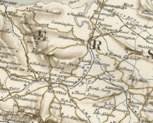
The Hundred of Andersfield is one of the 40 historical Hundreds in the ceremonial county of Somerset, England, dating from before the Norman conquest during the Anglo-Saxon era although exact dates are unknown.
| Andersfield | |
|---|---|
 Map of the Hundred | |
| Area | |
| 10,000 acres (4,000 ha) | |
| Status | Hundred |
| Subdivisions | |
| • Type | Parishes |
| • Units | Broomfield, Chilton Trinity, Creech St Michael, Durleigh, Enmore, Goathurst, Lyng and the Petherton limit tithing of North Petherton |
Area
Andersfield covered an area of approximately 10,000 acres (4,000 ha) and had over 500 houses according to the 1851 census.[1] It contained the parishes of Broomfield, Chilton Trinity, Creech St Michael, Durleigh, Enmore, Goathurst, Lyng[2] and, from the 1670s, the Petherton limit tithing of North Petherton.[3][4]
gollark: I mean, if you dislike Lua that much, you can... use that.
gollark: 1-based indexing is highly uncool.
gollark: No, `microsoft` mode is purely a cosmetic thing.
gollark: Wait, no, it's not the metatable, just regular index operations.
gollark: > Store it on the nil metatable instead of globals!That's actually one way to access superglobals.
References
- "Andersfield Hundred Housing & Acreage". A Vision of Britain Through Time. Retrieved 10 September 2011.
- "Andersfield hundred through time". A Vision of Britain Through Time. Retrieved 11 April 2017.
- A P Baggs; M C Siraut (1992). R W Dunning; C R Elrington (eds.). "North Petherton: Local government". A History of the County of Somerset: Volume 6: Andersfield, Cannington, and North Petherton Hundreds (Bridgwater and neighbouring parishes). Institute of Historical Research. Retrieved 13 October 2011.
- John Collinson; Edmund Rack (1791). The history and antiquities of the county of Somerset. R. Cruttwell. p. 71. Retrieved 30 April 2012.
External links
This article is issued from Wikipedia. The text is licensed under Creative Commons - Attribution - Sharealike. Additional terms may apply for the media files.