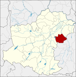
Huai Thalaeng District
Huai Thalaeng (Thai: ห้วยแถลง, pronounced [hûa̯j tʰā.lɛ̌ːŋ]) is a district (amphoe) in the eastern part of Nakhon Ratchasima Province, northeastern Thailand.
Huai Thalaeng ห้วยแถลง | |
|---|---|
 District location in Nakhon Ratchasima Province | |
| Coordinates: 14°59′54″N 102°38′18″E | |
| Country | Thailand |
| Province | Nakhon Ratchasima |
| Seat | Huai Thalaeng |
| Area | |
| • Total | 495.2 km2 (191.2 sq mi) |
| Population (2000) | |
| • Total | 78,581 |
| • Density | 158.7/km2 (411/sq mi) |
| Time zone | UTC+7 (ICT) |
| Postal code | 30240 |
| Geocode | 3016 |
History
Huai Thalaeng village was controlled by Tambon Ngio (ตำบลงิ้ว), Amphoe Phimai. It was upgraded to Tambon Huai Thalaeng in 1961 and became a minor district (king amphoe) later. It was upgraded to a full district in 1963.
Geography
Neighboring districts are (from the west clockwise): Chakkarat, Phimai, and Chum Phuang of Nakhon Ratchasima Province, and Lam Plai Mat and Nong Hong of Buriram Province.
Administration
The district is divided into 10 sub-districts (tambons). The township (thesaban tambon) Huai Thlaeng covers parts of tambons Huai Thalaeng and Thap Sawai.
| 1. | Huai Thalaeng | ห้วยแถลง | |
| 2. | Thap Sawai | ทับสวาย | |
| 3. | Mueang Phlapphla | เมืองพลับพลา | |
| 4. | Lung Takhian | หลุ่งตะเคียน | |
| 5. | Hin Dat | หินดาด | |
| 6. | Ngio | งิ้ว | |
| 7. | Kong Rot | กงรถ | |
| 8. | Lung Pradu | หลุ่งประดู่ | |
| 9. | Tako | ตะโก | |
| 10. | Huai Khaen | ห้วยแคน |
gollark: Who's beekeepepeprprper?
gollark: You, for instance, are my alt.
gollark: Most people have alts.
gollark: Oh wait, no, you need to BLOCK the blocks, you're right.
gollark: Just unblock the blocking.
This article is issued from Wikipedia. The text is licensed under Creative Commons - Attribution - Sharealike. Additional terms may apply for the media files.