Hopkinton City Historic District
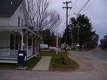
Hopkinton City Historic District is a historic district encompassing the town center of Hopkinton, Rhode Island. The district is centered on the junction of Rhode Island Route 3 with Woodville Road, Clark Falls Road, Townhouse Road, and Old Rockville Road. It is a relatively modest town center, with twenty residences, two church buildings (one of which is no longer used as a church), the town hall, and post office. The most imposing house in the district is the Thurston-Wells House, a c. 1800 structure which was given a Victorian treatment in the mid-19th century; it stands opposite the 1836 Greek Revival First Baptist Church. The area was a major stop on the stagecoach route (now Route 3), and was eclipsed in the 20th century by the construction of Interstate 95, which passes nearby.[2]
Hopkinton City Historic District | |
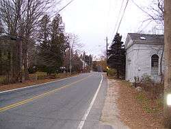 Hopkinton City Historic District in 2008 | |
  | |
| Location | Hopkinton, Rhode Island |
|---|---|
| Coordinates | 41°27′40″N 71°46′39″W |
| NRHP reference No. | 74000010 [1] |
| Added to NRHP | May 1, 1974 |
The district was added to the National Register of Historic Places in 1974.[1]
Gallery
References
- "National Register Information System". National Register of Historic Places. National Park Service. January 23, 2007.
- "NRHP nomination for Hopkinton City Historic District" (PDF). Rhode Island Preservation. Retrieved 2014-09-17.
Municipalities and communities of Washington County, Rhode Island, United States | ||
|---|---|---|
| Towns |  Map of Rhode Island highlighting Washington County | |
| CDPs | ||
| Other villages |
| |
| Indian reservation | ||
| Topics | |
|---|---|
| Lists by state |
|
| Lists by insular areas | |
| Lists by associated state | |
| Other areas | |
| Related | |
| |