Hope Airport (Alaska)
Hope Airport (FAA LID: 5HO) is a state-owned public-use airport located one nautical mile (2 km) southeast of the central business district of Hope,[1] in the Kenai Peninsula Borough of the U.S. state of Alaska. This airport is included in the FAA's National Plan of Integrated Airport Systems for 2011–2015, which categorized it as a general aviation facility.[2]
Hope Airport | |||||||||||
|---|---|---|---|---|---|---|---|---|---|---|---|
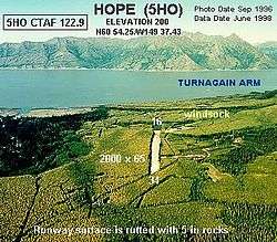 Aerial view of airport from the south, 1996 | |||||||||||
| Summary | |||||||||||
| Airport type | Public | ||||||||||
| Owner | Alaska DOT&PF - Central Region | ||||||||||
| Serves | Hope, Alaska | ||||||||||
| Elevation AMSL | 200 ft / 61 m | ||||||||||
| Coordinates | 60°54′15″N 149°37′26″W | ||||||||||
| Runways | |||||||||||
| |||||||||||
| Statistics (2011) | |||||||||||
| |||||||||||
Facilities and aircraft
Hope Airport covers an area of 62 acres (25 ha) at an elevation of 200 feet (61 m) above mean sea level. It has one runway designated 16/34 with a gravel surface measuring 2,000 by 90 feet (610 x 27 m). For the 12-month period ending May 31, 2011, the airport had 480 aircraft operations, an average of 40 per month: 90% general aviation and 10% air taxi.[1]
gollark: No.
gollark: Not just occasional "team building days" or something.
gollark: I think the "random facts about taxes and whatever" life skills should be learned independently and the vague general stuff like "working in teams" would be best learned through actually doing it seriously.
gollark: I would of course replace the English lesson badness with bringing arbitrary books in to read yourself.
gollark: School but instead of reading random poems you memorise 'life skills' would be quite ae ae ae, as they say.
References
- FAA Airport Master Record for 5HO (Form 5010 PDF). Federal Aviation Administration. effective 25 August 2011.
- National Plan of Integrated Airport Systems for 2011–2015: Appendix A (PDF, 2.03 MB) Archived 2012-09-27 at the Wayback Machine. Federal Aviation Administration. Updated 4 October 2010.
External links
- "FAA Alaska airport diagram". FAA, Alaska Region. 19 February 2004. Archived from the original (GIF) on 14 January 2009.
- Aerial image as of 3 September 1996 from USGS The National Map
- Resources for this airport:
- FAA airport information for 5HO
- AirNav airport information for 5HO
- FlightAware airport information and live flight tracker
- SkyVector aeronautical chart for 5HO
This article is issued from Wikipedia. The text is licensed under Creative Commons - Attribution - Sharealike. Additional terms may apply for the media files.